
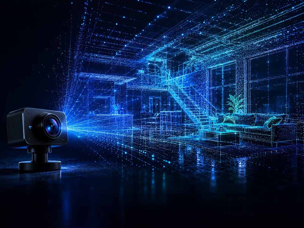
An ordinary RGB camera films a room, and while the recording runs, a dense 3D map of that same space grows alongside it. No laser, no depth sensor, just a video stream and a model that has learned to understand space from motion.
Visualization: A robot with a single RGB camera moves through an indoor space. The left half of the image shows the ordinary camera feed, while on the right, a dense point cloud of the same scene grows in real time, in sync with the camera’s motion, with a visible trajectory tracing the path the camera has traveled so far | Image: © Ulrich Buckenlei | XR Stager Online Magazine | VISORIC GmbH
3D reconstruction from camera images isn’t new. Classic photogrammetry and structure-from-motion have been turning photo sets into 3D models for years, offline, after the shoot is done, often taking minutes or hours to compute. For robotics, autonomous vehicles, or AR applications that need to know where they are right now, that just doesn’t cut it.
Robbyant, the embodied-AI unit inside Ant Group, tackled exactly this problem with LingBot-Map. Instead of processing a finished set of images, the system runs on a “see-as-you-go” principle: camera position and 3D scene structure are estimated frame by frame, while the video stream is still rolling.[1]
That shifts an important technical boundary. Spatial understanding used to be locked to specialized hardware, LiDAR scanners, depth cameras, structured light. LingBot-Map shows that a substantial chunk of that capability is achievable with a single, ordinary camera, paired with a model that has learned to interpret motion and geometry together.
For spatial computing, that’s a big deal. It complements topics like persistent object recognition or spatial displays with the foundation that feeds all of them in the first place: a continuously growing, reliable map of the space itself.
- Classic camera-based 3D reconstruction works offline, after the recording is complete.
- LingBot-Map (Robbyant, Ant Group) reconstructs camera position and 3D structure live, as filming happens.
- The system needs nothing more than a single, ordinary RGB camera, no specialized sensors.
- Spatial understanding becomes available on hardware people already own and use every day.
- The model is fully open source under the Apache 2.0 license.
This article explains how camera-based real-time 3D scanning works, why it rethinks classic SLAM from the ground up, where it still falls short of professional laser scanners, and what that unlocks for robotics, AR, and digital twins.
From Single Image to Continuous Map
Classic photogrammetry follows a fixed routine: gather as many photos of a scene as possible from different angles, then let an algorithm figure out offline how the camera must have moved between shots and how the scene fits together in 3D. The results can be stunningly precise, but only once the shoot is over.
For a robot moving through a room right now, that workflow simply doesn’t work. It needs to know where it is and what its surroundings look like in every single moment, not after some after-the-fact calculation. That’s exactly where classic SLAM comes in, Simultaneous Localization and Mapping, a technique that estimates position and map at the same time, continuously.
LingBot-Map builds on that core idea but swaps out the hand-engineered building blocks of classic SLAM systems, things like keyframe selection or iterative bundle adjustment, for a fully learned neural model.[2] Instead of hard-coded rules for when a frame becomes a reference point, the model itself decides what from the video stream so far is still worth keeping.
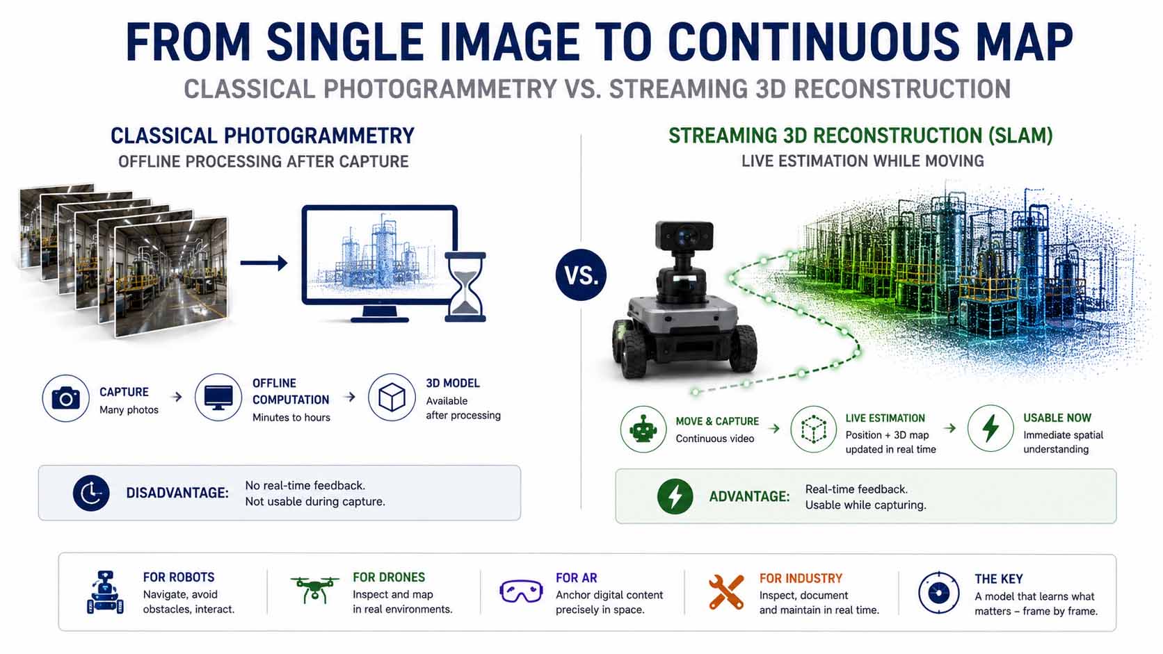
Classic photogrammetry processes images offline, after the shoot wraps. Streaming 3D reconstruction like LingBot-Map estimates camera position and scene geometry continuously, while the video stream is still running.
Infographic: From offline-computed photogrammetry to continuous streaming 3D reconstruction | Graphic: © Ulrich Buckenlei | XR Stager Online Magazine | VISORIC GmbH
This isn’t just a technical footnote. A cleaning robot, an inspection drone, or a pair of AR glasses can’t wait for a recording to finish and get processed offline, they need continuous, immediately usable spatial understanding to dodge obstacles, manipulate objects, or anchor digital content correctly in the real world.
That also raises the bar for the underlying architecture. It’s not enough to build a model that eventually delivers a precise map. It has to stay stable frame by frame, in real time, across thousands of frames, without compute or memory demands spiraling out of control.
- Classic photogrammetry computes 3D models offline, after image capture is complete.
- SLAM techniques estimate position and map simultaneously and continuously during movement.
- LingBot-Map replaces hand-engineered SLAM building blocks with a fully learned neural model.
- Robotics, AR, and inspection all need immediately usable, continuous spatial understanding.
- The architecture must stay stable across thousands of frames without blowing up compute or memory.
Getting a model to continuously figure out what from the video stream still matters sounds simple, but it’s actually the real engineering challenge. How LingBot-Map solves that problem, and why simply extending the context isn’t enough, is the subject of the next chapter.
Why a Simple Camera Stream Isn’t Enough for SLAM
The obvious fix for streaming 3D reconstruction would be to just feed a neural model the entire video history as context, the way large language models handle long text. The catch: with a video of ten thousand frames, that context grows so fast that compute and memory requirements blow past anything usable in real time.[3]
LingBot-Map solves this with an architecture called Geometric Context Attention. Instead of treating the entire history the same way, the model distinguishes three kinds of context: an anchor context for basic spatial grounding and scale, a local pose-reference window for dense geometric detail from the recent past, and a trajectory memory that compresses everything further back into compact tokens.[4]
The idea deliberately echoes classic SLAM, where different memory layers have long been handled separately, but shifts that logic entirely into a learnable system instead of hard-coded heuristics. The payoff is striking: the context the model has to process per frame grows roughly 80 times slower than with plain, unfiltered attention over the full history.[5]
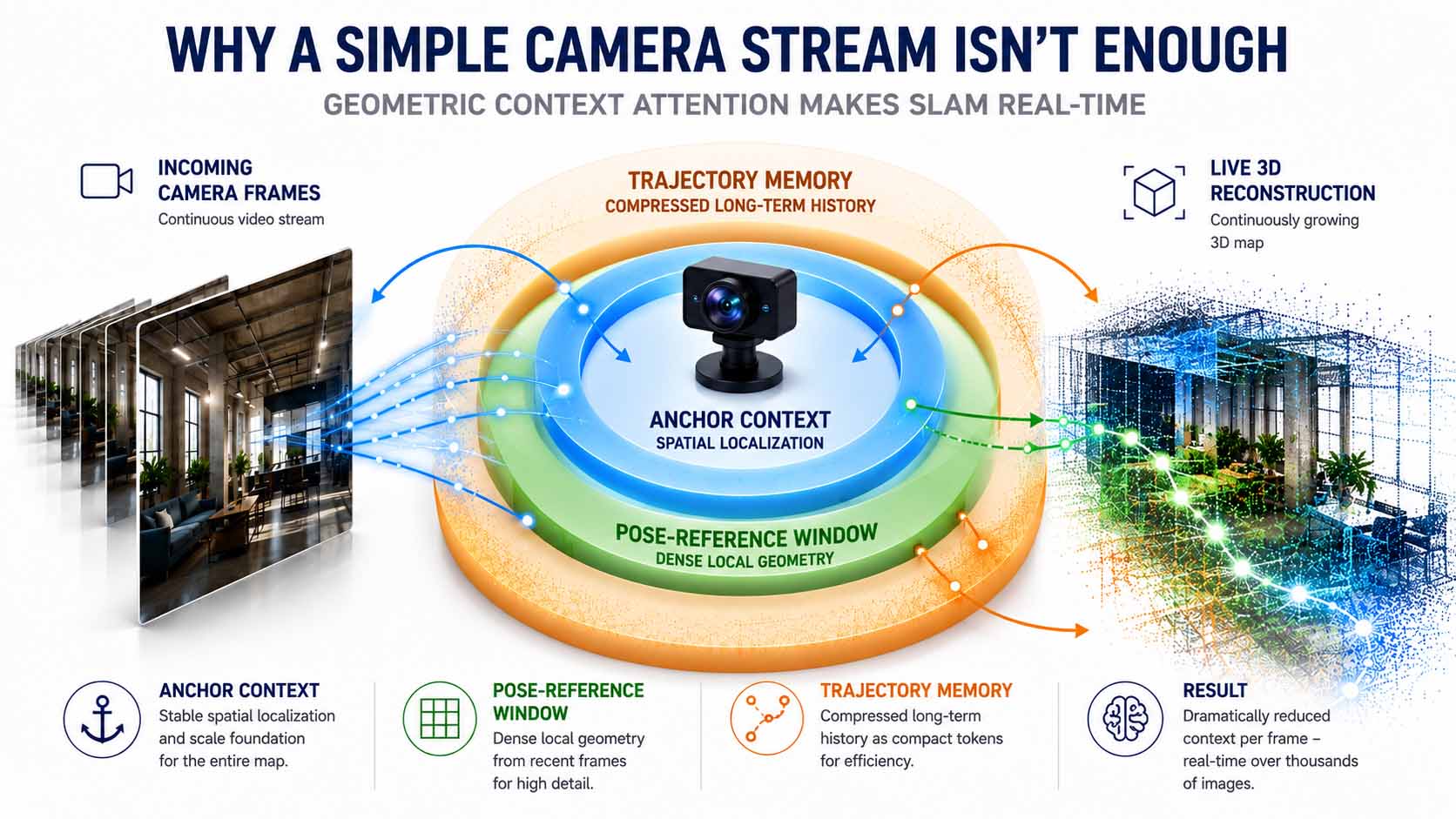
Geometric Context Attention distinguishes three context types, anchor, local pose window, and compressed trajectory memory. This split drastically reduces the required compute context and enables stable real-time reconstruction across thousands of frames.
Infographic: Architectural principle of Geometric Context Attention in LingBot-Map | Graphic: © Ulrich Buckenlei | XR Stager Online Magazine | VISORIC GmbH
Under the hood, the model runs on a ViT backbone initialized from DINOv2 weights, with alternating layers of classic frame-by-frame attention and the Geometric Context layers described above. A camera head predicts absolute position from this, a depth head infers scene geometry, both trained with a combined loss covering depth, absolute pose, and relative motion errors.[6]
In practice, this architecture hits an inference speed of roughly 20 frames per second at 518-by-378 resolution, staying stable across sequences of more than ten thousand frames without any noticeable accuracy drop. On the ETH3D benchmark, LingBot-Map scores a reconstruction F1 of 98.98, more than 21 percentage points ahead of the runner-up method.[7]
- Unfiltered video context would blow past compute and memory limits for real-time use.
- Geometric Context Attention distinguishes anchor context, pose-reference window, and trajectory memory.
- The required context per frame grows roughly 80 times slower than with plain attention.
- The model runs on a DINOv2-initialized ViT backbone with combined attention layers.
- On the ETH3D benchmark, LingBot-Map hits an F1 score of 98.98, clearly ahead of prior methods.
An engine this efficient doesn’t stay a lab demo for long. It provides exactly the data foundation that lets digital twins be fed in real time, as they’re being built. That’s the subject of the next chapter.
Digital Twins Now Emerge While You’re Filming
A digital twin traditionally relies on a separate capture step: a building or facility gets scanned, the result gets processed afterward, and only then is a model ready for analysis, planning, or visualization. Streaming 3D reconstruction changes that entirely, turning capture and model-building into one and the same continuous process.
As a camera moves through a room, whether handheld, mounted on a robot, or attached to an inspection drone, the 3D map grows along with it in real time. There’s no separate post-processing step standing between the recording and a usable model anymore. The digital twin comes into being during the walkthrough, not afterward.
For facility management, construction handovers, or plant inspections, that’s a serious practical upgrade. A technician can see immediately during a walkthrough which areas are already covered and where gaps remain, instead of discovering hours later, after processing, that a shot needs to be redone.
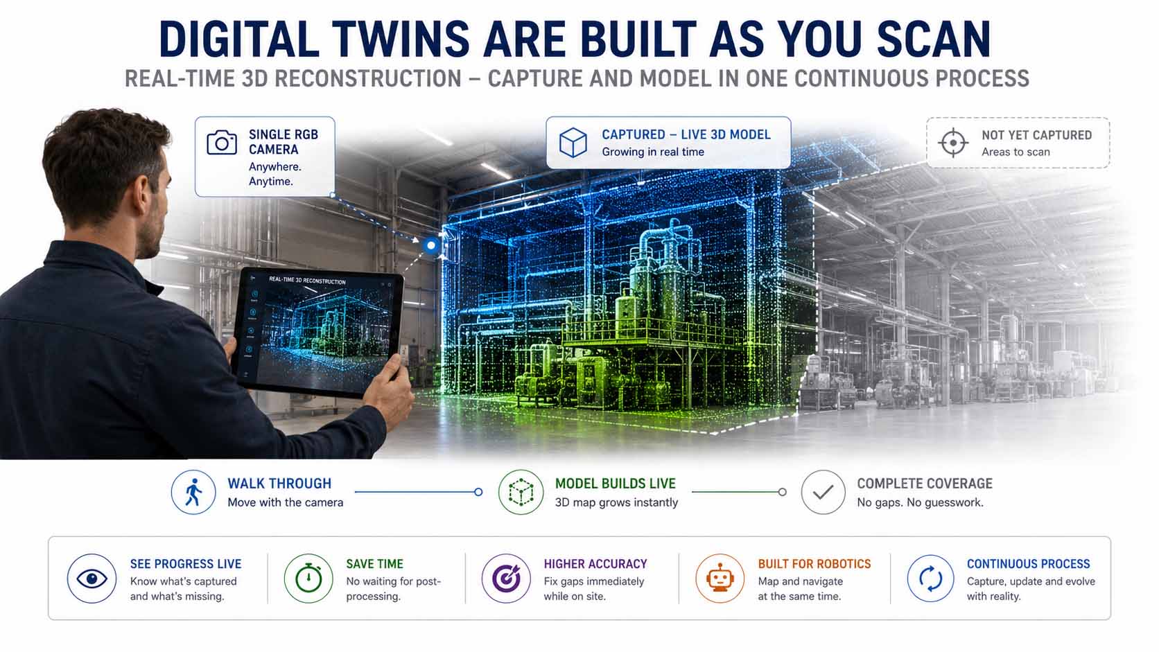
Streaming 3D reconstruction merges data capture and model-building into a single process. A digital twin takes shape during the walkthrough itself, not through separate post-processing.
Infographic: Camera-based real-time scanning as a new capture foundation for digital twins | Graphic: © Ulrich Buckenlei | XR Stager Online Magazine | VISORIC GmbH
Robotics benefits directly too. A mobile robot exploring an environment for the first time builds the spatial map it will use for navigation at the very same time. Mapping and using the map merge into one process, instead of staying separate steps, a principle classic SLAM systems already pursue in theory, but one LingBot-Map delivers with markedly higher geometric accuracy.
That puts camera-based streaming scanning in the same category as other building blocks of modern digital-twin infrastructure: not a one-time capture step, but an ongoing process that evolves right alongside reality.
- Streaming 3D reconstruction merges data capture and model-building into a single process.
- Digital twins take shape during the walkthrough, not through separate post-processing.
- Technicians see in real time which areas are already covered and where gaps remain.
- Mobile robots build their environment map while already using it for navigation.
- Camera-based scanning becomes an ongoing process rather than a one-time capture event.
As impressive as the results are, they don’t replace every existing capture technology. Where this approach still hits its limits, and why professional laser scanners still earn their keep, is the subject of the next chapter.
Why LiDAR Still Isn’t Obsolete
Whenever a new technology delivers impressive results with simpler hardware, the same fair question comes up fast: does this make existing precision equipment obsolete? For camera-based streaming 3D reconstruction, the honest answer is no, not everywhere.
Professional laser scanners still deliver the highest achievable accuracy and remain the right call for applications with tight technical tolerances, engineering, plant construction, or legally binding construction handovers. Camera-based models like LingBot-Map hit top scores on established benchmarks, but they work with estimated rather than physically measured depth, which is enough for many use cases, though not all of them.
The researchers behind the model are upfront about these limits too. LingBot-Map currently has no explicit loop-closure detection, the mechanism that corrects accumulated position drift once a previously visited location is reached again. Compressing trajectory history into a fixed number of tokens per frame can also lose fine geometric detail that would matter over very long sequences spanning tens of thousands of frames. And as a purely feed-forward method, the model skips the kind of test-time optimization that classic, iterative approaches use to sharpen results afterward.[8]
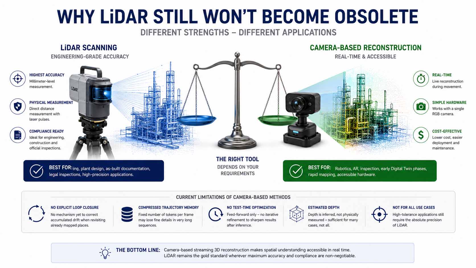
Professional laser scanners remain the right choice for applications demanding high accuracy. Camera-based streaming reconstruction shines where real-time capability and everyday hardware matter more than physically measured precision.
Infographic: Weighing professional laser scanners against camera-based real-time 3D reconstruction | Graphic: © Ulrich Buckenlei | XR Stager Online Magazine | VISORIC GmbH
This honesty is exactly what makes the technology easy to size up. For plenty of applications in robotics, augmented reality, inspection, or early-stage digital twins, camera-based scanning already delivers all the spatial information actually needed, without the acquisition and calibration overhead of a laser scanner. For applications with tight technical tolerances, though, LiDAR remains the tool of choice.
Knowing where that line sits lets you pick the right technology for the job, instead of pitting one against the other across the board. That same trade-off also determines exactly which industries can put camera-based streaming scanning to work today. That’s the subject of the next chapter.
- Professional laser scanners remain superior for applications with tight technical tolerances.
- Camera-based models estimate depth rather than measuring it physically.
- LingBot-Map currently has no explicit loop-closure detection.
- Compressed trajectory history can lose fine detail over very long sequences.
- As a feed-forward model, the system skips any after-the-fact test-time optimization.
A Technology for Robotics, AR, Inspection, and Digital Twins
Once it’s clear where camera-based streaming reconstruction is strong and where it isn’t, its real value becomes easy to place: anywhere real-time spatial understanding is needed and specialized sensor infrastructure isn’t available or worth the cost.
In mobile robotics, the technology enables navigation, obstacle avoidance, and complex object manipulation off a single camera, instead of relying on expensive LiDAR units.[9] For cost-sensitive service robots operating indoors, that lowers the barrier to entry considerably.
For augmented reality, continuous streaming scanning provides the spatial foundation needed to anchor digital content stably in the real world, no prior room mapping, no markers required.
In inspection and facility management, technicians can capture a complete, immediately usable 3D record of a facility in a single walkthrough with an ordinary camera, far faster and cheaper than with classic scanning gear.
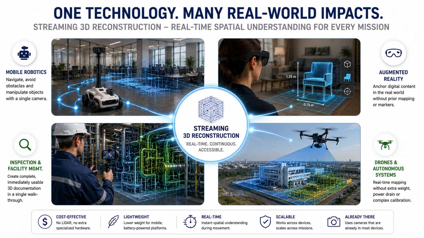
Camera-based streaming 3D reconstruction applies across industries: from mobile robotics and augmented reality to inspection, facility management, and automated drone surveys.
Infographic: Application fields for camera-based real-time 3D reconstruction in robotics, AR, and inspection | Graphic: © Ulrich Buckenlei | XR Stager Online Magazine | VISORIC GmbH
Autonomous vehicles and inspection drones benefit too, from a technology that delivers spatial understanding without adding weight, power draw, or calibration overhead from heavy sensors. For battery-powered, weight-sensitive platforms, that’s a direct, practical win.
What ties all these application fields together is the same underlying trait: spatial understanding is no longer locked to expensive specialized hardware, it runs on cameras that are already built into most devices anyway.
- Mobile robotics benefits from navigation and obstacle avoidance off a single camera.
- AR applications anchor digital content stably in space, no prior mapping or markers needed.
- Inspection and facility management create 3D documentation faster and cheaper.
- Autonomous vehicles and drones benefit from lower weight and power consumption.
- Spatial understanding becomes available on camera hardware that’s already built in.
This breadth of applications doesn’t exist despite the accessibility of the underlying hardware, it exists because of it. What it means when practically any camera can become a surveying instrument is the subject of the next chapter.
When Any Camera Becomes a Surveying Instrument
Spatial understanding used to be a privilege reserved for specialized equipment. Anyone who wanted to precisely measure an environment needed laser scanners, calibrated multi-camera rigs, or structured light, gear rarely found in the hands of individuals or small teams. Camera-based streaming reconstruction fundamentally shifts that accessibility.
A smartphone, an off-the-shelf webcam, or a small, lightweight camera on a service robot is enough to generate spatial understanding that used to require specialized hardware. That doesn’t just cut costs, it changes who actually gets access to this capability at all, small trade businesses, individual research teams, startups without a big hardware budget.
For businesses, that means a noticeably lower barrier to entry into applications that used to demand expensive specialized equipment. A facility management team can walk through a building with a tablet and produce the same kind of spatial documentation that once required hiring a specialized contractor with a laser scanner.
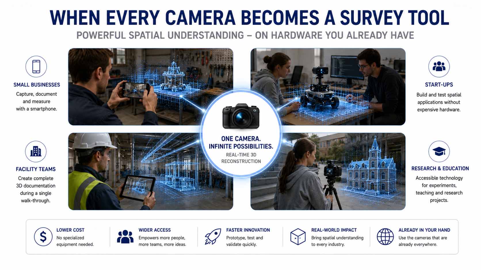
Camera-based streaming reconstruction makes spatial understanding accessible on everyday hardware people already own, instead of tying it to expensive specialized equipment.
Infographic: Democratizing spatial understanding through camera-based real-time 3D reconstruction | Graphic: © Ulrich Buckenlei | XR Stager Online Magazine | VISORIC GmbH
This accessibility also speeds up how fast new applications emerge. Once spatial understanding isn’t tied to a costly purchase anymore, the barrier for experiments, prototypes, and small pilot projects drops sharply. Teams can try things out before they commit to investing.
Long term, that means spatial understanding stops being treated as an exclusive capability reserved for large, well-equipped organizations, and starts becoming a basic function available on practically any camera, as long as the right model is running behind it.
- Spatial understanding used to be tied to expensive specialized hardware.
- Camera-based streaming reconstruction works on smartphones, webcams, and basic cameras.
- Smaller teams, startups, and individuals gain access to previously exclusive technology.
- The barrier to entry for pilot projects and experiments drops significantly.
- Spatial understanding shifts from an exclusive capability to a basic, widely available one.
This broad accessibility isn’t an accident, it’s a deliberate choice by the developers. Why LingBot-Map was consistently released as an open research project, and what that means for the technology’s future, is the subject of the next chapter.
Open Research Instead of Closed Systems
Powerful spatial perception systems are often developed inside individual companies and stay locked there. That’s a serious roadblock for advancing an entire research field: results are hard to verify independently, and smaller teams without access to comparable resources get shut out of major progress.
Robbyant took a different path with LingBot-Map. Model weights, training code, and evaluation tools were released in full under the Apache 2.0 license, one of the most permissive open-source licenses out there, explicitly allowing both private and commercial use.[10] The GitHub repository already has over 13,000 stars and more than 1,400 forks, a clear sign of how much practical relevance developers see in the project.[11]
LingBot-Map doesn’t stand alone. It’s part of a broader series of openly released foundation models for embodied AI from the same team, including LingBot-Depth for high-precision spatial perception, LingBot-VLA as a general-purpose vision-language-action model, LingBot-World as a world model for environment simulation, and LingBot-VA for autoregressive video-action robot control.[12] Together, these models form a connected, openly accessible technology stack for physical AI.
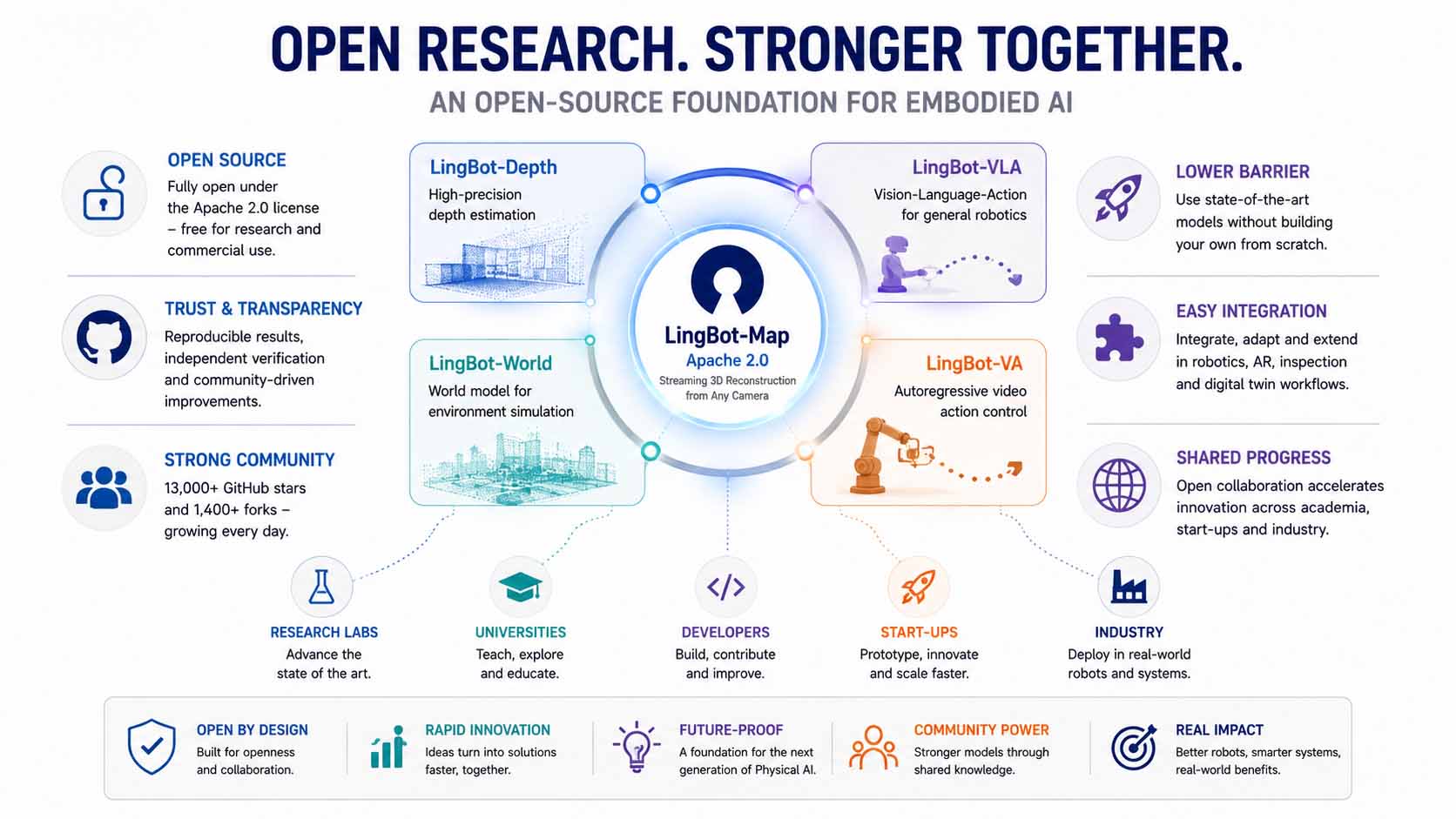
LingBot-Map is part of an openly released technology stack for embodied AI. Together with related models for depth estimation, action control, and world simulation, it forms a continuous, open-source foundation for physical AI.
Infographic: The open LingBot technology stack for embodied AI and streaming 3D reconstruction | Graphic: © Ulrich Buckenlei | XR Stager Online Magazine | VISORIC GmbH
For companies outside pure research, this openness means a much lower barrier into a demanding technology. Instead of building a comparable model from scratch, LingBot-Map can be deployed directly, integrated into existing robotics or AR projects, and extended as needed.
At the same time, the project’s open nature points to a broader trend in physical AI research: progress increasingly comes not from individual closed platforms, but from openly accessible foundation models advanced together by a broad community of researchers, startups, and industry.
- LingBot-Map is fully open source under the permissive Apache 2.0 license.
- The GitHub repository has over 13,000 stars and more than 1,400 forks.
- The model is part of a broader series of open foundation models for embodied AI.
- Together, these models form a connected, open technology stack for physical AI.
- Open research lowers the barrier for companies without their own AI research teams.
Open research is the foundation. Its real significance only becomes clear in the bigger picture of a development that reaches far beyond a single model. Why camera-based streaming 3D reconstruction is becoming a core building block of the next generation of physical AI is the subject of the final chapter.
Streaming 3D Reconstruction as the Next Evolution of Physical AI
Physical AI describes systems that don’t just process language or images, but perceive, orient themselves, and act within the physical world. For that to work, they need more than the ability to recognize objects in a picture. They need a fundamental understanding of space itself, continuous, in real time, independent of specialized sensors.
Much AI research has so far focused on recognition within individual frames: what object is visible, what action is happening. Camera-based streaming reconstruction extends that focus to the spatial dimension itself. A system understands not just what it sees, but where it is and how the surrounding space is structured in three dimensions, continuously updated as it moves.
This capability pairs directly with other current developments in physical AI, like persistent object recognition, which re-identifies objects over time. Where persistent object recognition provides memory for individual objects, streaming 3D reconstruction provides memory for the space itself. Together, both building blocks form the foundation for systems that don’t just see, but genuinely understand space and remember it.
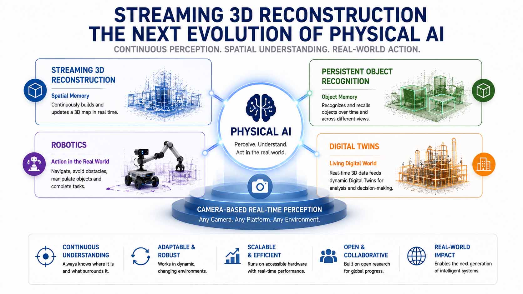
Streaming 3D reconstruction provides spatial memory, persistent object recognition provides memory for individual objects. Together, both building blocks form a solid foundation for the next generation of physical AI.
Infographic: Streaming 3D reconstruction as a complementary building block alongside persistent object recognition within physical AI | Graphic: © Ulrich Buckenlei | XR Stager Online Magazine | VISORIC GmbH
For companies investing in robotics, automation, or digital twins, this points to a clear strategic conclusion. Systems that build spatial understanding only once, in a separate capture step, will eventually hit a wall once they need to handle continuously changing environments. Systems built around continuous streaming reconstruction are designed from the ground up for exactly those conditions.
Research projects like LingBot-Map show that this capability is already technically mature, scientifically validated, and openly accessible today. The path from an academic publication to broad industrial adoption has become considerably shorter than it was just a few years ago.
- Physical AI needs continuous spatial understanding, not just momentary image recognition.
- Streaming 3D reconstruction provides spatial memory, persistent object recognition provides object memory.
- Both building blocks combine into a solid foundation for robotics and digital twins.
- One-time capture steps hit clear limits in continuously changing environments.
- Open research significantly shortens the path from academic results to industrial application.
This brings the article full circle. What starts with a single camera and a video stream is turning into a foundational technology for the next generation of robotics, digital twins, and physical AI. What this continuous reconstruction actually looks like in practice is shown in the following video.
When a Camera Becomes a 3D Scanner
The previous chapters have shown how camera-based streaming 3D reconstruction works, where it still falls short of professional laser scanners, and which industries are already putting it to practical use. How convincing the results actually are becomes most obvious in a direct, side-by-side comparison of camera footage and growing 3D reconstruction.
The following video shows exactly that comparison: on the left, ordinary RGB video shot with a standard camera; on the right, the live-growing 3D reconstruction computed frame by frame by LingBot-Map. You can see the system continuously estimating camera motion and reconstructing the environment as the recording happens, with zero post-processing.[13]
Watching the point cloud over time is especially telling: edges and surfaces stay geometrically coherent even across longer camera movements, a direct result of the Geometric Context Attention described in Chapter 2, which keeps position errors from piling up unchecked.
Video: Camera-based real-time 3D reconstruction with LingBot-Map | Visuals by original creators Robbyant, Ant Group | Analysis, script, editing, and video production: © Ulrich Buckenlei | XR Stager Online Magazine | VISORIC GmbH
The video makes it clear that camera-based 3D scanning isn’t some purely academic concept anymore, it already works today on off-the-shelf camera footage. For companies weighing robotics, AR, or digital-twin applications, this example shows just how close a practical rollout really is.
At the same time, the video makes the key conceptual difference obvious: it’s not the reconstruction of a single frame that stands out, it’s the geometric consistency across thousands of frames. That’s exactly what separates simple depth estimation from genuine, reliable spatial understanding.
- The video shows a direct comparison between RGB camera footage and live-growing 3D reconstruction.
- Camera motion is estimated continuously, and the environment reconstructed with zero post-processing.
- Edges and surfaces stay geometrically coherent even across longer camera movements.
- The technology already works on off-the-shelf camera footage without specialized sensors.
- What matters is geometric consistency across thousands of frames, not any single reconstruction.
This example makes tangible where spatial perception in physical AI is heading: from isolated, single-shot depth estimates to a continuous, reliable understanding of the entire surrounding space, generated from nothing more than an ordinary video stream.
From Camera Feed to Practical Spatial Model
Camera-based streaming 3D reconstruction doesn’t come from a single technology, it comes from the interplay of an efficient model architecture, carefully matched use cases, and a realistic read on where it still falls short of professional scanning gear. Only when use case, hardware, and model are thought through together from day one does a spatial model emerge that actually holds up in daily use.
Many successful projects start with a clearly scoped pilot, a facility walkthrough shot on a standard camera, a proof of concept for robot navigation, or an AR application with spatial anchoring. That lets you test accuracy, integration effort, and real value under real conditions before scaling up to something bigger.

15 years of experience in 3D, AI, and XR: the VISORIC expert team from Munich.
Image: © Ulrich Buckenlei | XR Stager Online Magazine | VISORIC GmbH
VISORIC builds practical solutions for camera-based 3D reconstruction, robotic perception, and digital twins, from strategic consulting through to deployment-ready applications. Our expert team from Munich combines streaming 3D reconstruction, computer vision, and real-time 3D into solutions companies can put to work right away in robotics, facility management, or AR.
- Consulting and concept development for camera-based 3D reconstruction and computer vision.
- Integrating streaming 3D models into robotics, AR, and digital-twin projects.
- Delivering pilot projects through to company-wide spatial capture solutions.
Want to bring camera-based 3D scanning, a robotics application, or a spatial capture system to your company?
Talk to the VISORIC expert team from Munich about streaming 3D reconstruction, computer vision, digital twins, and modern spatial computing platforms. Together, we’ll turn your idea into a reliable, practical solution for robotics, inspection, or facility management.
Contact:
Email: info@visoric.com
Phone: +49 89 21552678
Sources and References
- Robbyant (Ant Group). Ant Group’s Robbyant Unveils LingBot-Map: A Streaming 3D Reconstruction Model for Real-Time Spatial Understanding. Press release, April 2026.
- Chen, L.-Z. et al. Geometric Context Transformer for Streaming 3D Reconstruction. arXiv:2604.14141.
- Chen, L.-Z. et al. Geometric Context Transformer for Streaming 3D Reconstruction. Positioning against classic SLAM systems with hand-engineered building blocks, arXiv:2604.14141.
- Chen, L.-Z. et al. Geometric Context Transformer for Streaming 3D Reconstruction. Technical description of Geometric Context Attention with anchor, pose-reference, and trajectory-memory context, arXiv:2604.14141.
- Emergent Mind. Geometric Context Transformer for 3D Reconstruction. Technical summary of the model architecture, ViT backbone, and training procedure.
- Robbyant. LingBot-Map benchmark results on ETH3D, Oxford Spires, 7-Scenes, and Tanks and Temples. Press release, April 2026.
- Chen, L.-Z. et al. Geometric Context Transformer for Streaming 3D Reconstruction. Section on limitations: missing loop-closure detection, compressed trajectory memory, no test-time optimization, arXiv:2604.14141.
- explainx.ai. LingBot-Map — Streaming 3D Reconstruction Guide. Positioning of application fields between classic SLAM and offline reconstruction methods.
- GitHub. Robbyant/lingbot-map repository. Source code, licensing information, and technical documentation.
- Robbyant (Ant Group). Overview of the LingBot model stack: LingBot-Depth, LingBot-VLA, LingBot-World, LingBot-VA. Press release, April 2026.
- Robbyant (Ant Group). Demonstration material for LingBot-Map, direct comparison of RGB video and real-time 3D reconstruction.
- VISORIC practice projects in computer vision, robotics, digital twins, and spatial computing.
- XR Stager platform for real-time 3D, digital twins, knowledge AI, and industrial spatial computing applications.
Contact Us:
Email: info@xrstager.com
Phone: +49 89 21552678
Contact Persons:
Ulrich Buckenlei (Creative Director)
Mobil +49 152 53532871
Mail: ulrich.buckenlei@xrstager.com
Nataliya Daniltseva (Projekt Manager)
Mobil + 49 176 72805705
Mail: nataliya.daniltseva@xrstager.com
Address:
VISORIC GmbH
Bayerstraße 13
D-80335 Munich