
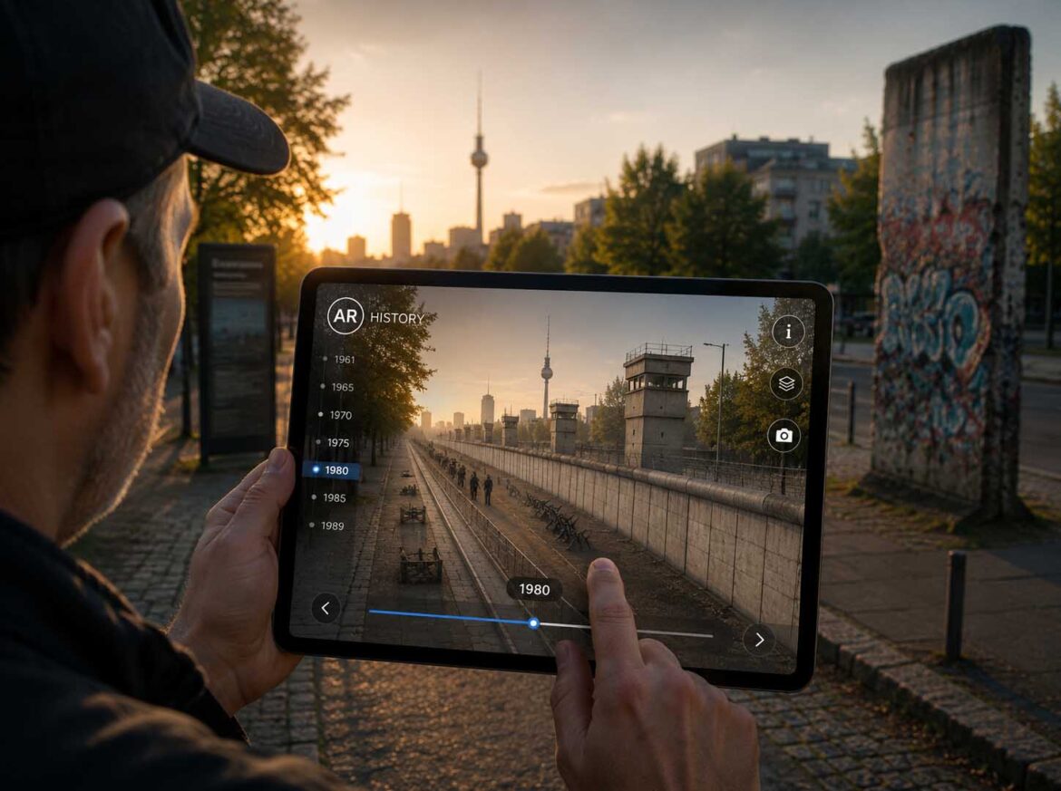
A location-based digital twin reconstructs the Berlin Wall directly at its original historic location, making history immediately accessible through Spatial Computing.
Visualization: Spatial Computing combines Augmented Reality, digital twins, and historical reconstructions to create a new form of immersive knowledge transfer at the original historical site | Image: © Ulrich Buckenlei | XR Stager Online Magazine | VISORIC GmbH
History is inseparably linked to places. It was at these locations that significant events occurred, cities were founded, borders were drawn, buildings were constructed, and political decisions were made. Over time, however, many of these places have changed dramatically. Buildings disappeared, entire districts were redesigned, and historical traces often survive only in archives, photographs, or a few remaining fragments. Even when standing at the original locations, it is often difficult to imagine what these places once looked like.
At the same time, Spatial Computing is emerging as one of the most important technologies of the next generation of digital applications. What began with Augmented Reality and Virtual Reality is evolving into a comprehensive spatial computing approach, where digital content merges precisely with the physical world. Powered by real-time 3D, artificial intelligence, Computer Vision, georeferencing, and digital twins, new opportunities arise to present information not only on screens but directly at its real-world location in a spatially immersive way.
This development is particularly significant in the field of cultural heritage. For the first time, historic sites can be digitally reconstructed exactly where they originally existed. Visitors no longer experience buildings, streets, border fortifications, or archaeological structures solely through photographs, scale models, or information panels, but directly at their original locations. Past and present merge into a shared spatial experience, creating a new form of knowledge transfer that meaningfully complements traditional museums, memorial sites, and audiovisual media.
A current example is the digital reconstruction of the Berlin Wall. Large sections of the former border fortifications have disappeared. In many places, it is now almost impossible to comprehend the true scale of the wall, the border strip, and the surrounding infrastructure that once shaped the urban landscape. Through a location-based Augmented Reality application, the historical structure becomes visible again at its original full scale. Only then do its dimensions, distances, and spatial relationships become truly understandable—something that photographs or books alone can hardly convey.
This also fundamentally changes our understanding of digital twins. While the technology has traditionally been associated with industry, mechanical engineering, building technology, and smart factories, digital twins of historic sites are becoming increasingly important. They combine historical information, three-dimensional reconstructions, spatial data, and interactive content with a real-world location. As a result, a static place of remembrance evolves into a digitally enhanced experiential environment where knowledge is directly connected to its physical surroundings.
The development becomes even more compelling with the integration of artificial intelligence. Historical photographs can be analyzed, missing architectural elements reconstructed, eyewitness accounts evaluated, and content automatically translated into multiple languages. Computer Vision and spatial anchoring ensure that digital reconstructions appear precisely at their original locations. This creates adaptive information spaces capable of tailoring content to each visitor’s interests, language, and individual context.
New opportunities also emerge for cultural institutions, museums, tourism destinations, and educational organizations.
Historic sites become easier to understand, complex historical relationships can be experienced spatially, and lost architecture becomes visible once again. At the same time, entirely new possibilities arise for preserving cultural knowledge digitally and making it accessible for future generations.
- Spatial Computing connects historical reconstructions directly to their original locations.
- Digital twins bring lost architecture and historical spatial relationships back to life.
- Augmented Reality adds a spatial dimension to memorial sites, museums, and historical city tours.
- Artificial intelligence supports reconstruction, translation, and personalized knowledge transfer.
- Historic sites are evolving into intelligent digital experience and information spaces.
This article explains how Spatial Computing transforms historic sites into digital twins, explores the technologies driving this evolution, and demonstrates why it extends far beyond traditional Augmented Reality applications. Using the digital reconstruction of the Berlin Wall as a practical example, it illustrates how digital reconstructions make history directly accessible at the places where it happened and highlights the new opportunities this creates for culture, tourism, education, research, and heritage preservation.
Why History Needs a Digital Twin
Historic sites are among the most valuable sources of information in our society. They document political events, technological progress, cultural change, and the everyday lives of past generations. At the same time, they are constantly evolving. Buildings disappear, urban structures change, and many historic locations survive only as fragments or in historical photographs. Even where individual buildings have been preserved, their original spatial impact is often difficult to comprehend.[3]
For decades, the primary mission of museums, heritage conservation, and archaeology was to document and preserve these sites as authentically as possible. Information panels, scale models, photographs, and films helped explain historical contexts. Despite these extensive efforts, one limitation always remained: visitors still had to imagine what the original site looked like. An unavoidable gap existed between today’s reality and the historical past—a gap that could only be bridged through imagination.
This is precisely where a new generation of digital technologies begins. Spatial Computing connects digital content directly with the physical environment, making historic buildings, streetscapes, and even entire landscapes visible again exactly where they once existed. Instead of displaying a virtual reconstruction on a screen, a spatially anchored digital twin merges the past with the present. This fundamentally changes not only how history is presented, but also how people perceive and understand it.[4]
The following diagram illustrates this transformation. While traditional heritage conservation primarily focuses on preserving existing structures and historical documents, a digital twin enhances a historic site with an additional digital layer. Physical remains, historical sources, three-dimensional reconstructions, and spatially anchored information merge into a unified knowledge platform. As a result, visitors experience history not merely as a retrospective but as a spatial experience directly at the original location.
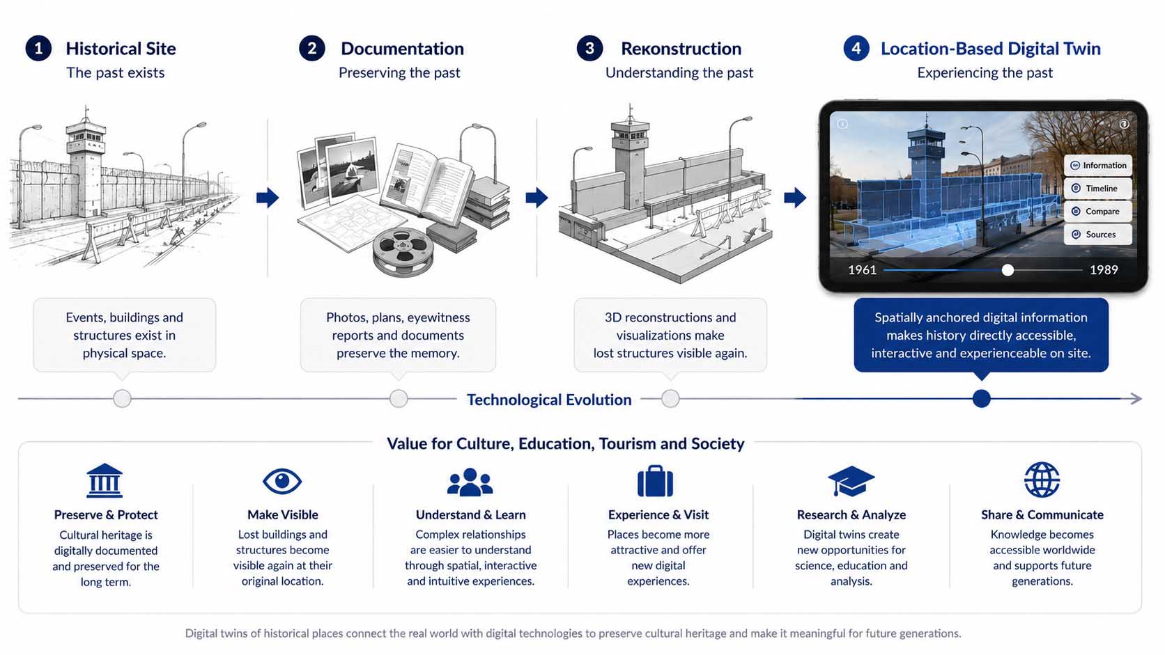
Digital twins extend historic sites with a spatially anchored digital layer, connecting the past, the present, and digital information into a unified experience.
Diagram: Evolution from the original historic site through documentation and reconstruction to a location-based digital twin | Graphic: © Ulrich Buckenlei | XR Stager Online Magazine | VISORIC GmbH
The diagram illustrates how the interpretation of historic sites is fundamentally changing. While earlier reconstructions were typically limited to individual media such as photographs, scale models, or information panels, today’s technologies create a continuous connection between the physical location and digital information. Buildings can be reconstructed at full scale, historical events can be placed within their original spatial context, and additional information can be displayed directly at the corresponding location. This opens entirely new opportunities for museums, memorial sites, guided city tours, and educational institutions to communicate complex historical relationships in a far more vivid and intuitive way.
A striking example is the Berlin Wall. Large sections of the former border fortifications have disappeared or survive only as isolated remnants. Only through precise spatial reconstruction does it become possible to understand the true dimensions of the border system and the profound impact it once had on the urban landscape. Visitors gain a completely new understanding of distances, proportions, and historical relationships that can hardly be conveyed through the remaining wall fragments alone.
Digital twins are therefore evolving into a new form of knowledge transfer. They not only preserve historic places digitally but also make them directly accessible at their original locations. This represents their greatest value: they combine scientific documentation, modern visualization technologies, and immersive spatial experiences into a unified platform for culture, education, and tourism.
- Historic sites continuously evolve and often lose their original spatial character.
- Digital twins enrich real-world locations with precisely anchored digital reconstructions.
- Spatial Computing connects the past and the present directly at the original site.
- Museums, memorial sites, and historical city tours gain entirely new possibilities for knowledge transfer.
- History is no longer only documented but becomes spatially accessible where it originally happened.
The foundation for this approach consists of numerous technologies that precisely connect digital information with the physical world. The next chapter explains how GPS, Computer Vision, georeferencing, photogrammetry, real-time 3D, and artificial intelligence work together to make this possible.
How Historic Sites Are Digitally Reconstructed
The digital reconstruction of a historic site begins long before visitors launch an Augmented Reality application on a smartphone or tablet. Every spatially anchored visualization is based on a multi-stage process that combines historical sources, modern capture technologies, three-dimensional models, and precise location data. The goal is to reconstruct lost buildings, streetscapes, and landscapes as accurately as possible and align them precisely with their original real-world locations.[5]
The process begins with the available historical sources. Photographs, architectural drawings, maps, aerial imagery, film footage, surveying data, and eyewitness accounts provide valuable information about the site’s former appearance. The more diverse the available sources, the more accurately the original buildings, infrastructure, and spatial relationships can be reconstructed. Historical reconstruction is therefore not only a design task but also a process of scientific validation and interpretation.
Existing parts of a historic site can also be captured using modern Reality Capture technologies. Drone photography, terrestrial laser scanning, LiDAR, 360-degree imaging, and photogrammetry generate highly accurate spatial data of today’s environment. These datasets provide the geometric foundation on which historical reconstructions are aligned. As a result, digital models can be accurately integrated with existing buildings, streets, terrain, and surviving historical remains.
The collected information is then transformed into three-dimensional models. Depending on the application, these may include manually created 3D assets, CAD data, polygonal meshes, photogrammetric models, or increasingly 3D Gaussian Splatting. While traditional 3D models offer excellent control, optimization, and animation capabilities, modern capture techniques enable highly realistic representations of complex surfaces and entire environments.[6]
The following diagram illustrates the complete workflow. Historical documents and preserved physical remains provide the foundation. Reality Capture records the current site, while 3D reconstruction digitally restores lost structures. All data is then georeferenced, spatially anchored, and integrated into a Spatial Computing application. Only through this combination does a location-based digital twin emerge.
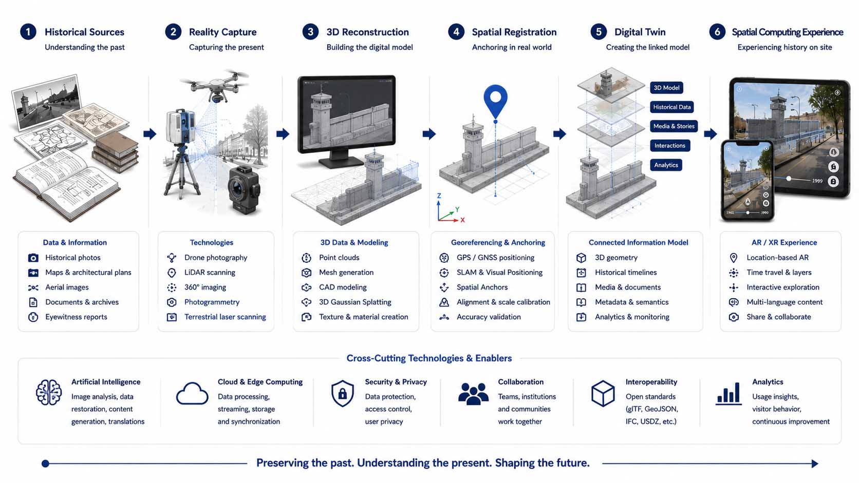
Historical sources, Reality Capture, 3D reconstruction, and spatial anchoring together provide the foundation for accurate digital twins.
Diagram: Workflow from historical sources and Reality Capture through 3D reconstruction, georeferencing, and Spatial Anchors to a location-based Spatial Computing application | Graphic: © Ulrich Buckenlei | XR Stager Online Magazine | VISORIC GmbH
The diagram demonstrates that a digital twin is not created by a single technology. Instead, it is the interaction of multiple data and processing layers that produces a reliable spatial model. Historical sources describe the past, modern capture technologies document the present, and three-dimensional reconstructions bridge the gap between these two points in time.
Spatial anchoring plays a crucial role in this process. Digital models must not only look realistic but also appear at exactly the correct position, scale, and orientation. GPS and GNSS provide the initial geographic positioning, while Computer Vision, SLAM algorithms, and Spatial Anchors significantly improve local accuracy and ensure that digital content remains stably aligned with its real-world environment, even while users move.
Especially in large-scale reconstructions, even small positioning errors can reduce the credibility of the experience. A wall, building, or historic streetscape must appear exactly where it originally stood. Only then can visitors intuitively understand distances, dimensions, and spatial relationships. The precision of spatial anchoring is therefore just as important as the quality of the 3D model itself.
Artificial intelligence is also becoming increasingly important throughout this workflow. AI can analyze historical image collections, identify similar structures, enhance damaged photographs, and assist in reconstructing missing architectural elements. It can also automatically transcribe historical texts, evaluate eyewitness accounts, and associate historical information with specific locations or periods. Scientific validation remains essential, but AI dramatically accelerates the analysis and preparation of large historical datasets.
The original 3D model gradually evolves into a connected knowledge platform. Buildings become linked with historical sources, timelines, narratives, and multimedia content. Visitors can explore different historical periods, examine individual structures in greater detail, and access contextual information directly at the original location. The digital twin therefore represents not only the physical appearance of a place but also its historical evolution and the knowledge associated with it.
- Historical photographs, architectural drawings, and historical records form the foundation of every reliable reconstruction.
- LiDAR, photogrammetry, and drone imagery accurately capture today’s original location.
- 3D models and Gaussian Splatting bring lost buildings and environments back to life.
- GPS, Computer Vision, SLAM, and Spatial Anchors precisely position digital content in the real world.
- Artificial intelligence supports the analysis, preparation, and integration of historical information.
This technical workflow forms the foundation for a new generation of historical storytelling. However, the decisive factor is not only how accurately a site is reconstructed, but also how visitors interact with that reconstruction. Only when users can switch between historical periods, explore spatial relationships, and experience information directly at the original location does a digital model become an interactive historical experience.
What Spatial Computing Really Means
The term Spatial Computing is appearing more and more frequently today, yet it is often used interchangeably with Augmented Reality or Virtual Reality. In reality, Spatial Computing describes a much broader concept. It refers to a new form of human-computer interaction in which digital information no longer appears exclusively on screens but is directly integrated with the physical environment. Buildings, streets, objects, and entire landscapes become a spatial user interface where digital content can be precisely anchored and interactively experienced.[7]
This evolution began with traditional desktop computers, where the mouse, keyboard, and monitor served as the only interfaces. Smartphones then made digital information mobile while adding cameras, GPS, and sensors. Augmented Reality introduced the ability to overlay virtual content onto the camera view. Mixed Reality took this a step further by enabling digital objects to respond to their physical surroundings. Spatial Computing brings all of these developments together into a unified platform where computers understand their environment and permanently connect digital content with real-world locations.
Although these terms are often confused, they describe distinctly different technologies. Virtual Reality creates fully virtual worlds while blocking out the physical environment. Augmented Reality enriches the real world with digital information. Mixed Reality additionally enables interaction between real and virtual objects. Spatial Computing goes beyond all of these approaches: the physical environment is continuously analyzed, mapped, and understood. As a result, digital content can remain permanently anchored to a specific location, adapt to environmental changes, and interact with both people and their surroundings.[8]
This approach opens entirely new possibilities, particularly for historic sites. A digitally reconstructed streetscape no longer appears arbitrarily on a display but exactly where it originally existed. Visitors move through the real urban environment while digital buildings, historical information, and past events become visible at their precise historical locations. The computer understands the surrounding space just as the visitor experiences it, merging both into a single immersive environment.
The following diagram illustrates the evolution from traditional computer systems to modern Spatial Computing platforms. It clearly shows that Spatial Computing is not merely another technology but the logical evolution of digital user interfaces. Screens become spaces, applications evolve into digital twins, and information transforms into location-based, interactive experiences.
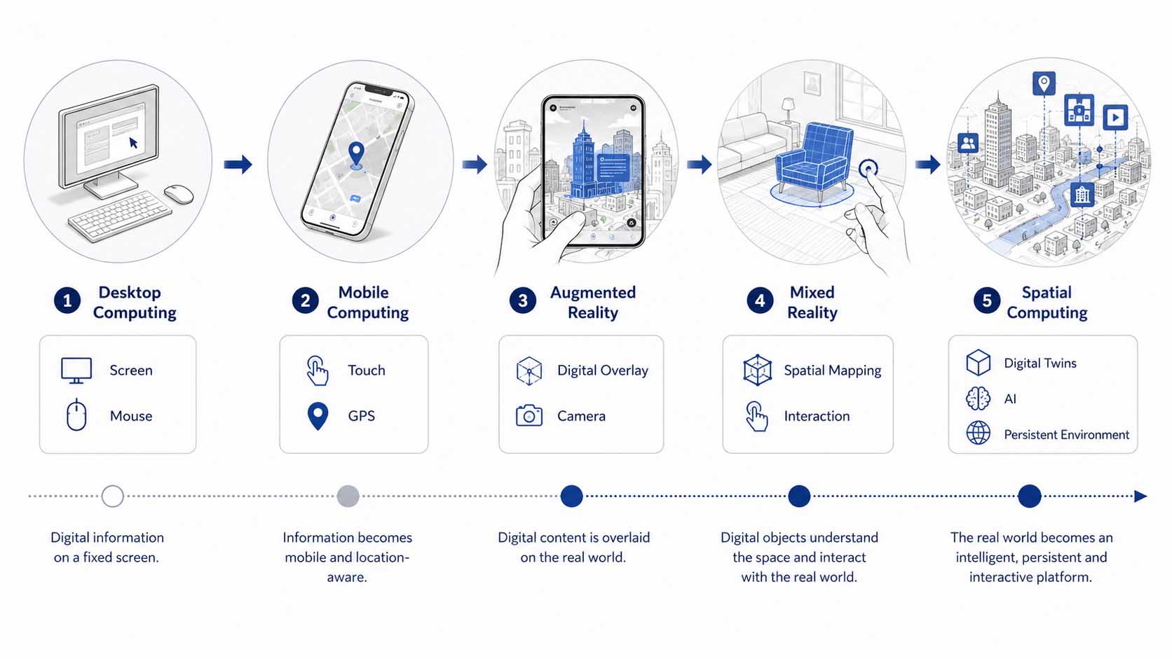
Spatial Computing transforms human-computer interaction from traditional screen-based interfaces into persistent digital experience spaces seamlessly connected to the physical world.
Diagram: The evolution from Desktop Computing through Mobile Computing, Augmented Reality, and Mixed Reality to Spatial Computing | Graphic: © Ulrich Buckenlei | XR Stager Online Magazine | VISORIC GmbH
The diagram illustrates how each stage of technological development has expanded the possibilities of digital interaction. While desktop computers were tied to a fixed workplace, smartphones made digital information available anywhere and at any time. Augmented Reality brought digital content into the physical world for the first time. Mixed Reality added spatial understanding and interaction. Finally, Spatial Computing combines all of these technologies into a unified platform where digital content becomes a permanent part of the real environment.
For visitors to historic sites, this represents a fundamental shift in perspective. History is no longer something that is merely observed—it is experienced directly at the place where it happened. Digital reconstructions remain spatially anchored, respond to user movement, and can display contextual information, eyewitness accounts, or interactive content. This gives rise to digital twins that extend far beyond the capabilities of traditional museum applications.
- Spatial Computing permanently connects digital content with the physical environment.
- Virtual Reality, Augmented Reality, and Mixed Reality are all part of this technological evolution.
- Computers analyze their surroundings and understand spatial relationships.
- Historic sites become interactive digital experience spaces.
- Digital twins provide the foundation for a new generation of location-based applications.
Now that the technological foundations have been established, the next question is: How do visitors actually experience these digital twins on site? That is the focus of the following chapter.
When History Becomes an Interactive Experience
A digital reconstruction can show what a historic site once looked like. Its true value, however, emerges only when visitors can explore the location independently, compare different historical periods, and access additional information directly within the surrounding environment. A three-dimensional model thus evolves into an interactive experience where history is not merely observed but discovered step by step.[9]
Traditional media usually present historical events from a fixed perspective. Photographs capture a single moment, films follow a predefined narrative, and physical models often represent only one specific point in time. Spatial Computing removes these limitations. Visitors can move freely through the real environment, change their perspective, and decide for themselves which content they want to explore in greater detail. Their physical position becomes an integral part of the story.
One of the most powerful features is the ability to switch between different historical periods. A streetscape may first appear as it exists today and then be reconstructed for different years. Buildings emerge or disappear, infrastructure changes, and political developments become spatially understandable. Time is no longer communicated solely as a chronological sequence but as a visible transformation of a real place.
A location-based reconstruction of the Berlin Wall demonstrates how effective this approach can be. At an original preserved section, visitors can directly compare today’s surroundings with earlier stages of the former border fortifications. On a mobile device, wall segments, watchtowers, barriers, and additional structures appear exactly where they historically stood. As visitors move through the site, the digital reconstruction remains precisely anchored and can be viewed from different perspectives.
The following diagram illustrates how historical interpretation evolves from passive observation into an interactive spatial experience. Photographs and information panels initially provide isolated facts. Digital reconstructions make lost structures visible. Spatial Computing adds movement, multiple time layers, interaction, and context-aware media. A linear presentation becomes a personalized historical journey that visitors can explore at their own pace.
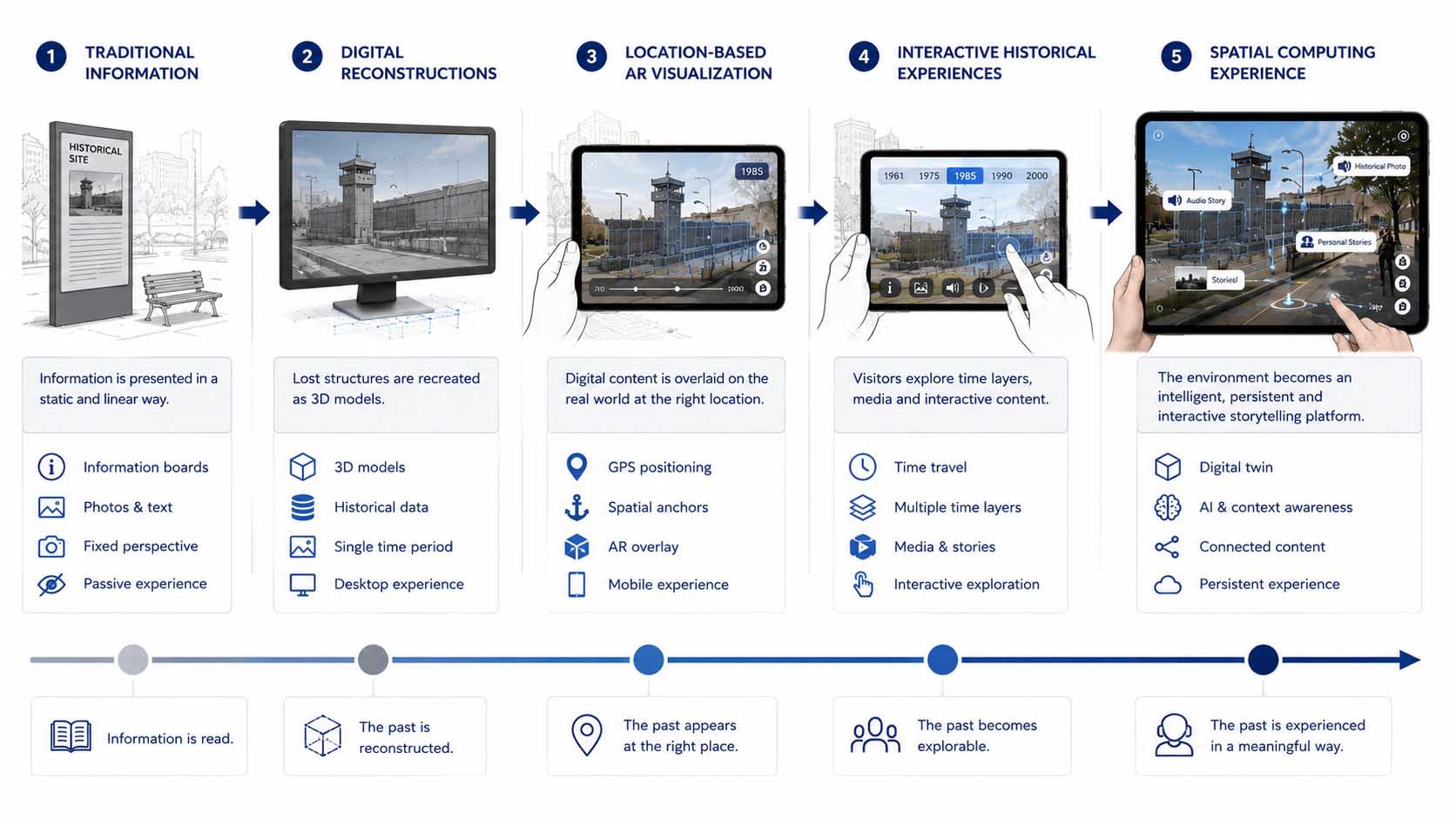
Spatial Computing combines movement, multiple time layers, historical reconstructions, and interactive media into an immersive historical experience.
Diagram: The evolution from traditional information media through digital reconstructions to interactive historical experiences with time travel, Spatial Anchors, and immersive storytelling | Graphic: © Ulrich Buckenlei | XR Stager Online Magazine | VISORIC GmbH
The diagram demonstrates that interactivity is about far more than pressing buttons. What truly matters is that visitors can influence the perspective, sequence, and depth of the presented information themselves. They decide which historical period to explore, which elements to compare, and when to access additional content. This creates a personal connection to history that adapts to individual interests.
An additional dimension is created by integrating historical photographs, films, audio recordings, and eyewitness accounts. These media no longer have to be presented separately from the physical location. Instead, they can appear exactly where an event occurred or where a particular structure once stood. Eyewitness reports gain immediate spatial context, while historical photographs can be compared directly with today’s environment.[10]
The atmosphere of a historic site can also be conveyed more effectively. Color grading, ambient sounds, spoken language, music, or monochrome visualizations can distinguish different historical periods from one another. These design elements do not replace scientific documentation, but they help make historical contexts more emotionally accessible. Especially when dealing with abstract or difficult-to-imagine events, the combination of factual accuracy and spatial storytelling can leave a lasting impression.
Museums, memorial sites, and educational institutions benefit from an entirely new approach to historical interpretation. Instead of guiding every visitor through the same linear exhibition, content can be organized modularly and adapted to different age groups, languages, and levels of prior knowledge. Children receive a more visual introduction, specialists gain access to in-depth source material, and international visitors experience the same content in their preferred language.
At the same time, maintaining historical integrity remains essential. Interactive experiences must not oversimplify, distort, or turn historical events into mere entertainment. Sources must remain transparent, reconstructions should be clearly identified as such, and uncertainties must be communicated openly. Only when technological innovation is combined with scientific responsibility does a digital memorial become truly credible.
- Spatial Computing enables visitors to explore historic sites from multiple spatial perspectives.
- Multiple historical time layers reveal how buildings, borders, and urban structures evolved.
- Photographs, films, and eyewitness accounts can be directly connected to their original locations.
- Interactive content can be adapted to visitors’ language, age, and level of knowledge.
- Scientific sources and transparent documentation ensure the credibility of historical reconstructions.
When historic sites become interactive in this way, the impact extends far beyond the museum experience. Tourism, education, research, and cultural heritage interpretation all gain powerful new tools for making knowledge more engaging, accessible, and sustainable.
When Historic Sites Become Digital Twins
The term Digital Twin originally emerged in industry. It describes a digital representation of a machine, production facility, or building that is continuously connected to real-time data. Engineers use digital twins to analyze processes, simulate changes, and make informed decisions without having to work directly on the physical asset. Today, this principle is expanding far beyond industrial applications, opening entirely new possibilities for cities, cultural heritage, and historic sites.[11]
A historical digital twin represents much more than the geometry of a building or a streetscape. It combines spatial reconstructions with historical photographs, maps, eyewitness accounts, scholarly sources, and multimedia content. The result is a digital knowledge platform that connects the past with the present. Visitors no longer experience history only through information panels or museum exhibitions but directly at the original location where historical events took place.
The Berlin Wall provides a particularly compelling example. Today, the remaining wall segments represent only a small fraction of the former border fortifications. A location-based digital twin enriches these surviving fragments with reconstructed buildings, watchtowers, border barriers, and historical scenes that no longer exist. At the same time, photographs, historical documents, eyewitness reports, and archival film footage can be displayed precisely where they were originally created. Individual reconstructions thus become a fully interconnected historical information environment.[12]
A digital twin is not static—it evolves continuously. New scientific discoveries, additional historical sources, and current research findings can be integrated at any time. Unlike a printed information panel, a digital twin remains dynamic and grows together with our historical knowledge. This creates a long-term platform for research, education, and cultural heritage preservation.
The following diagram illustrates the difference between a traditional historical reconstruction and a fully developed digital twin. While a reconstruction primarily visualizes buildings, a digital twin connects spatial models with historical sources, multimedia content, real-time information, artificial intelligence, and interactive user interfaces. History therefore becomes not only visible but digitally explorable.
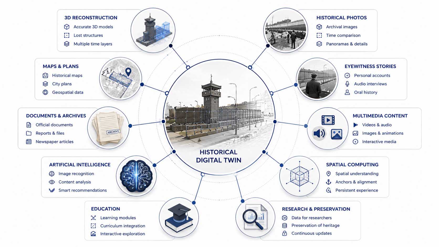
A historical digital twin combines spatial reconstructions with historical sources, multimedia, artificial intelligence, and interactive information to create a unified knowledge platform.
Diagram: The evolution from a historical 3D reconstruction to an intelligent digital twin integrating historical sources, multimedia, Spatial Computing, and artificial intelligence | Graphic: © Ulrich Buckenlei | XR Stager Online Magazine | VISORIC GmbH
The diagram makes it clear that a digital twin is far more than a three-dimensional model. It serves as the digital interface between historical knowledge and the physical location. Different information sources are interconnected, multimedia content is synchronized, and spatially accurate visualizations provide visitors with a much deeper and more intuitive understanding of historical relationships.
This approach becomes even more powerful when multiple historical periods are combined. A building can be visualized in different construction phases, political transformations can be illustrated, and urban development can be explored across decades. A static reconstruction evolves into a living archive that continuously tells the story of a place.
New opportunities also arise for researchers and heritage conservation professionals. Archaeological discoveries, restoration projects, and new research findings no longer need to wait for the next exhibition. Instead, they can be integrated directly into the digital twin and made available to visitors around the world almost in real time.
- Historical digital twins combine spatial reconstructions with scholarly sources.
- Photographs, maps, films, and eyewitness accounts are spatially anchored to their original locations.
- New research findings can be continuously integrated.
- Visitors experience history as an interactive knowledge platform rather than a static reconstruction.
- Digital twins provide a long-term foundation for education, research, and cultural heritage preservation.
The next stage of development begins when digital twins no longer simply store information but actively analyze, enrich, and personalize it. This is where artificial intelligence comes into play.
When Artificial Intelligence Makes History Easier to Understand
A historical digital twin initially represents existing knowledge in digital form. Its full potential, however, is realized only when artificial intelligence helps analyze, connect, and personalize that knowledge. As a result, a static reconstruction evolves into an intelligent information system that actively assists visitors and makes historical relationships easier to understand.[13]
Until now, visitors have generally needed to search for information manually. They read information panels, navigate menus, or look up additional sources themselves. Artificial intelligence fundamentally changes this process. It can recognize which objects are within a visitor’s field of view, identify the questions being asked, and determine which historical period is of particular interest. Based on this context, relevant information is presented automatically.
Rather than creating new historical narratives, AI provides an intelligent gateway to existing scholarly sources. Photographs, eyewitness accounts, maps, documents, and audiovisual materials can be combined dynamically according to the visitor’s location and context. Visitors receive exactly the information that matches their current position, viewing direction, and historical surroundings. This makes history significantly easier to understand without compromising its scientific accuracy.[14]
This approach becomes even more compelling through modern language models. Instead of reading lengthy information panels, visitors can simply ask questions. They may inquire about specific events, buildings, or historical figures. The answers appear directly within the spatial context of the historic site and can be enhanced with images, maps, or three-dimensional reconstructions.
The following diagram illustrates how artificial intelligence connects multiple information sources within a historical digital twin. Sensors and Spatial Computing first determine the visitor’s location and viewing direction. AI then analyzes the spatial context and accesses historical archives, maps, photographs, eyewitness accounts, and 3D reconstructions. The result is a personalized knowledge experience that dynamically adapts to each visitor.
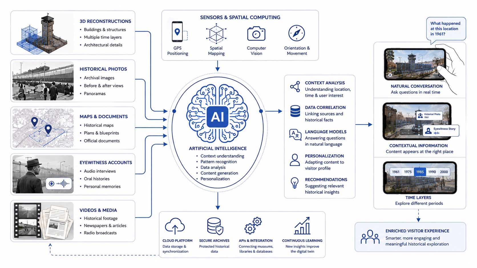
Artificial intelligence combines historical sources, spatial information, and visitor interactions into a personalized knowledge platform.
Diagram: Interaction of Artificial Intelligence, Spatial Computing, historical sources, Computer Vision, language models, and Digital Twins for adaptive knowledge delivery | Graphic: © Ulrich Buckenlei | XR Stager Online Magazine | VISORIC GmbH
The diagram demonstrates that artificial intelligence is not intended to replace historical research. Its primary role is to intelligently connect existing knowledge and deliver the right information at the right moment. This dramatically reduces the complexity of extensive historical archives. Visitors gain direct access to relevant information without having to search through large amounts of data themselves.
Museums and memorial sites also benefit from this approach. Content can be translated automatically into multiple languages, adapted to different age groups, and presented in accessible formats. International visitors receive the same scientifically validated information without requiring every piece of content to be manually produced in numerous language versions.
In the long term, historical digital twins may even continue learning over time. New research findings, restored photographs, and additional eyewitness accounts can be integrated immediately. Artificial intelligence automatically categorizes this information and makes it instantly available to visitors. The result is a knowledge platform that continuously evolves alongside historical research.
- Artificial intelligence automatically connects historical sources.
- Visitors receive context-aware information based on their location and viewing direction.
- Language models enable natural conversations about historical events.
- Multilingual content and accessibility can be largely automated.
- New research findings can be continuously integrated into the digital twin.
Historical digital twins are therefore evolving from digital reconstructions into intelligent knowledge systems. The next step goes even further. Entire cities could eventually become interconnected historical digital twins, linking individual sites into comprehensive digital cultural landscapes.
How Spatial Computing Is Redefining Cultural Heritage
The reconstruction of historic sites is only one of many applications of modern Spatial Computing technologies. Wherever physical locations, historical information, and digital content are connected, new opportunities emerge for education, research, tourism, and heritage preservation. The true value lies not simply in bringing lost buildings back virtually, but in permanently connecting knowledge with its original location.[15]
Thousands of historical sites around the world face similar challenges. Buildings change over time, archaeological sites are built over, and many traces of the past survive only in archives or historical photographs. Digital twins make it possible for the first time to bring all of this information together permanently and make it accessible regardless of the physical condition of a site. This creates a new form of digital heritage preservation that complements historic structures without altering their original substance.
This approach becomes even more powerful when individual historical sites are connected. Instead of isolated applications, a shared digital cultural landscape emerges, allowing visitors to explore different cities, monuments, and historical periods using the same principles. Digital twins become part of a scalable knowledge infrastructure that can be continuously expanded and updated.[16]
Educational institutions also benefit significantly from this development. Students no longer learn history exclusively from books but experience historical events directly at their original locations. Universities gain new opportunities for research and teaching, while museums can extend their exhibitions far beyond the boundaries of their physical buildings. History is documented independently of location while simultaneously being experienced exactly where it happened.
The following diagram illustrates how historical digital twins can evolve into a global infrastructure for cultural heritage. Individual historic sites form the foundation. Through Spatial Computing, cloud platforms, and artificial intelligence, interconnected knowledge environments emerge for museums, cities, educational institutions, and visitors. Local reconstructions gradually become part of a global digital cultural heritage network.
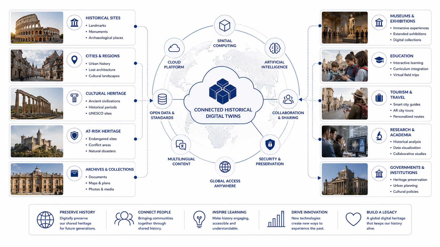
Connected digital twins link historic sites around the world into a shared platform for education, research, and cultural heritage.
Diagram: Networking historical digital twins through Spatial Computing, cloud platforms, artificial intelligence, and shared knowledge infrastructures for culture, education, and tourism | Graphic: © Ulrich Buckenlei | XR Stager Online Magazine | VISORIC GmbH
The diagram highlights that digital twins should no longer be viewed as isolated applications. Their full potential emerges only when many historical sites are interconnected. Shared standards, cloud platforms, and open interfaces make it possible to provide content across locations and continuously expand it. Museums, archives, and research institutions can share their data and integrate new discoveries directly into existing digital twins.
For visitors, this creates entirely new possibilities. Historical relationships no longer end at the boundaries of a single exhibition. Instead, events, buildings, and historical periods can be connected and experienced within a broader spatial context. Traveling between different historic sites becomes a journey through interconnected knowledge environments.
Cities also benefit from this development. Historical information can be seamlessly integrated into tourism services, educational programs, and guided city tours. At the same time, a long-term digital record of cultural heritage is created that remains preserved regardless of physical changes and can be continuously expanded.
- Digital twins preserve historical knowledge regardless of the physical condition of a site.
- Historic sites can be connected worldwide through shared digital platforms.
- Museums, archives, and universities benefit from a shared digital knowledge infrastructure.
- Visitors experience history across multiple locations, cities, and historical periods.
- Spatial Computing forms the foundation of a new generation of digital cultural heritage experiences.
This raises one final question: Where will this technology evolve in the years ahead? That outlook forms the conclusion of this article.
The Future of Digital Twins for Historic Sites
The digitalization of historic sites is still in its early stages. Today, most applications are developed as standalone solutions for museums, memorial sites, or tourist attractions. In the coming years, however, these isolated applications are likely to evolve into an interconnected infrastructure in which digital twins, artificial intelligence, and Spatial Computing work seamlessly together. Historic sites will no longer merely be documented but will become intelligent knowledge environments that continuously evolve.[17]
Modern Reality Capture technologies, highly accurate 3D reconstructions, and precise spatial anchoring already enable impressive digital experiences. With every new generation of sensors, mobile devices, and AI systems, these applications will become even more realistic, interactive, and accessible. Smartphones and tablets are only the beginning. Future AR glasses and Spatial Computing devices will integrate digital content almost effortlessly into everyday life, allowing people to experience historic sites without visible technological barriers.
At the same time, digital twins are evolving from static reconstructions into living knowledge platforms. New research findings, restored photographs, and archaeological discoveries can be incorporated immediately. Artificial intelligence supports the analysis of large datasets, connects diverse historical sources, and helps visitors intuitively understand complex historical relationships. This creates a system that continuously grows and improves with every new piece of information.[18]
One of the most exciting developments will be the connection of many historic sites into a shared digital infrastructure. Instead of developing isolated applications, cities, museums, archives, and research institutions could interconnect their digital twins. Visitors would no longer experience history only at a single location but could explore historical events across entire regions, countries, or historical periods. History would become a spatially connected knowledge network.
The following diagram summarizes this evolution. It illustrates the journey from individual historical reconstructions to intelligent digital twins and ultimately to a globally connected Spatial Computing platform. Artificial intelligence, cloud technologies, Reality Capture, and interactive user interfaces merge into a new generation of digital cultural heritage experiences.
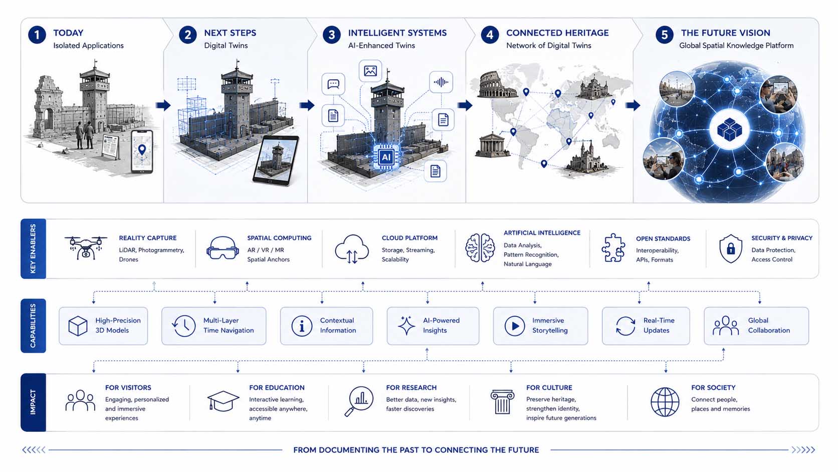
Historical digital twins are evolving into intelligent, globally connected knowledge platforms for culture, education, and research.
Diagram: The evolution of historical digital twins into a globally connected Spatial Computing infrastructure integrating artificial intelligence, cloud technologies, Reality Capture, and interactive knowledge platforms | Graphic: © Ulrich Buckenlei | XR Stager Online Magazine | VISORIC GmbH
The diagram illustrates that the future will involve far more than changing the way historic sites are visualized. It represents an entirely new approach to digital knowledge transfer. Buildings, streets, monuments, and landscapes become spatial interfaces where historical information appears precisely where it originated. Visitors gain an immediate connection between place, time, and historical events.
This development also opens new scientific opportunities. Historical sources become easier to compare, research findings can be published more rapidly, and international collaboration becomes significantly more efficient. Schools, universities, and museums likewise benefit from shared standards, open interfaces, and a centralized knowledge base that can be continuously expanded.
The true innovation therefore lies not in a single application or a specific generation of hardware. Instead, it emerges from the intelligent integration of reality, digital twins, artificial intelligence, and spatial interaction. Together, these technologies create a new generation of digital cultural heritage experiences that do not replace history but make it more understandable, accessible, and permanently preserved.
- Historical digital twins are evolving into intelligent knowledge platforms.
- Artificial intelligence connects historical sources, media, and spatial information.
- Reality Capture and Spatial Computing create highly accurate location-based experiences.
- Connected platforms enable international collaboration and research.
- History becomes interactively accessible directly at its original location.
The future will not simply digitize history. It will connect the past, the present, and human knowledge at their original locations. This is the true potential of Spatial Computing: historic sites become living digital twins that allow future generations to experience history exactly where it happened.
When Digital History Comes Alive at the Original Site
The reconstruction of historic sites is one of the most exciting application areas for Spatial Computing. Modern Reality Capture technologies, precise spatial anchoring, and digital twins already make it possible to visualize lost buildings and historical events exactly where they once existed. This creates an entirely new form of knowledge transfer in which the past and present merge directly within the physical environment.
The real strength of this technology, however, extends far beyond three-dimensional visualization. Only through the combination of Spatial Computing, artificial intelligence, Computer Vision, and location-based digital twins do intelligent information systems emerge that actively guide visitors. Historical sources, photographs, maps, eyewitness accounts, and interactive 3D models become part of a unified spatial knowledge platform.
The following video demonstrates this approach using a real-world example at the Berlin Wall. The on-site demonstration shows how digital reconstructions can be precisely aligned with the original location. At the same time, it provides a glimpse into how historic sites can evolve into interactive digital twins that make history directly accessible where it actually happened.
Video: Demonstration of a location-based Spatial Computing application at the Berlin Wall | Analysis, narration, editorial work, and video production: © Ulrich Buckenlei | XR Stager Online Magazine | VISORIC GmbH
Today, many historical reconstructions are still developed as standalone applications for museums and memorial sites. In the future, they could evolve into globally connected digital knowledge environments that continuously expand through new research findings, artificial intelligence, and additional historical sources. Visitors would no longer simply observe historic places but interact with them and ask individual questions directly at the original location.
This development becomes even more compelling through the integration of generative artificial intelligence. Language models can explain historical relationships in an accessible way, automatically translate content into multiple languages, and personalize information according to each visitor’s age, background knowledge, or interests. A traditional reconstruction thus evolves into an intelligent digital guide that delivers personalized historical knowledge without compromising scientific accuracy.
In the long term, entire cities, cultural landscapes, and historical regions could become interconnected digital twins. Buildings, streets, monuments, and archaeological sites would become part of a shared spatial knowledge infrastructure that permanently connects education, research, tourism, and cultural heritage.
- Spatial Computing permanently connects historic sites with digital information.
- Digital twins make lost architecture and historical developments spatially accessible.
- Artificial intelligence supports the analysis, translation, and personalization of historical content.
- Interactive knowledge platforms connect museums, archives, and research institutions.
- History becomes understandable, accessible, and sustainably preserved directly at its original location.
The greatest transformation therefore lies not in a single application or a new generation of devices. It lies in the intelligent integration of historical sources, spatial information, digital twins, and artificial intelligence. This is where the next generation of digital cultural heritage begins—where history is no longer merely documented but experienced once again at the place where it actually happened.
From a Historical Digital Twin to a Successful Pilot Project
The development of digital twins for historic sites does not begin with a finished application or a particular hardware platform. The first step is identifying which historical knowledge should be communicated spatially and what value visitors, museums, or educational institutions should gain. Only when historical content, digital reconstructions, and the appropriate software architecture are planned together do long-term successful applications emerge.
Many successful projects intentionally start small. A single historic site, museum exhibition, gallery, or guided city tour is often more effective than attempting a large-scale implementation from the outset. This makes it possible to evaluate technical capabilities, user experience, and content under realistic conditions before expanding the solution step by step.
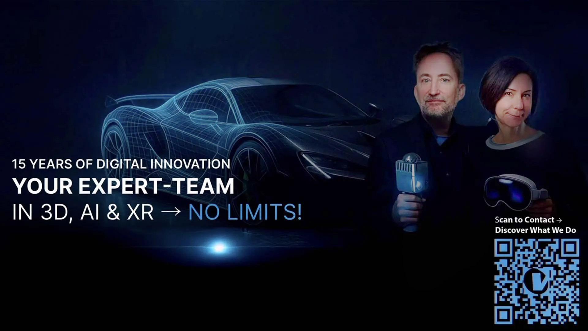
Successful Spatial Computing projects begin with a clearly defined use case, scientifically validated content, and a scalable Digital Twin platform.
Visualization: Spatial Computing, Historical Digital Twins, Reality Capture, Artificial Intelligence, interactive 3D applications, and scalable knowledge platforms | Image: © Ulrich Buckenlei | XR Stager Online Magazine | VISORIC GmbH
How museums, cities, and institutions can get started:
- Select a clearly defined historic site or exhibition as a pilot project.
- Organize historical sources, photographs, maps, and eyewitness material using scientific standards.
- Use Reality Capture, photogrammetry, or laser scanning to create accurate digital twins.
- Develop interactive experiences for smartphones, tablets, and Spatial Computing devices.
- Initially use artificial intelligence for knowledge delivery, translation, and personalization.
- Evaluate the pilot project before expanding it to additional sites or historical topics.
Historical digital twins offer far more than traditional museum applications. The same technologies are equally suitable for city marketing, tourism, universities, industrial heritage, corporate archives, and educational initiatives. The key is an open platform capable of integrating future content, new research findings, and emerging technologies.
The VISORIC expert team in Munich supports companies, museums, cities, and public institutions in developing Spatial Computing solutions—from the initial concept through productive deployment.
- Strategy development and feasibility studies for Spatial Computing and Digital Twin projects.
- Reality Capture, photogrammetry, laser scanning, and high-quality 3D reconstruction.
- Development of interactive applications for smartphones, tablets, WebXR, and XR devices.
- Digital twins, real-time 3D, and scientifically accurate visualization of historical content.
- Software development, cloud platforms, and centralized management of complex knowledge databases.
- Integration of artificial intelligence, Computer Vision, and intelligent user guidance.
- Pilot implementation, deployment, and scalable expansion of advanced Spatial Computing platforms.
Are you planning a historical digital twin, an interactive museum solution, or a Spatial Computing project for culture, education, or tourism?
Talk to the VISORIC expert team in Munich about a concrete pilot project, the right software architecture, and the development of compelling spatial user experiences.
Contact:
Email: info@visoric.com
Phone: +49 89 21552678
Sources and References
- Google Arts & Culture. Digital preservation of cultural heritage and virtual access to historical sites.
- Apple: Vision Pro and Spatial Computing. Foundations of spatial user interfaces and immersive digital experiences.
- UNESCO World Heritage Centre. Conservation, preservation, and documentation of cultural heritage.
- ICOMOS: International Council on Monuments and Sites. Principles for heritage conservation and digital documentation.
- RealityCapture / Epic Games. Photogrammetry and digital reconstruction workflows.
- Eurographics & SIGGRAPH. Research on 3D reconstruction, Gaussian Splatting, and Reality Capture technologies.
- Apple Developer Documentation. Spatial Computing concepts and spatial user interfaces.
- Microsoft Mixed Reality Documentation. Spatial Anchors, Computer Vision, and Mixed Reality technologies.
- ICOM: International Council of Museums. Interactive museum experiences and digital storytelling.
- Europeana. Digital cultural heritage, archives, and historical media collections.
- NVIDIA Omniverse. Digital twins, real-time simulation, and collaborative virtual environments.
- Siemens. Industrial Digital Twins and Digital Twin technologies as the foundation for intelligent spatial systems.
- OpenAI. Large Language Models and AI-assisted knowledge retrieval.
- Microsoft AI Research. Artificial intelligence, Computer Vision, and multimodal information systems.
- UNESCO. Digital transformation strategies for cultural heritage and education.
- European Commission. Common European Data Space for Cultural Heritage.
- Gartner. Emerging technologies and the future of Spatial Computing and AI.
- IDC. Worldwide Augmented Reality, Virtual Reality, and Spatial Computing market forecasts.
- Original video footage and field testing of the location-based Spatial Computing application at the Berlin Wall.
- Current research and industry developments in Spatial Computing, historical digital twins, and immersive cultural heritage technologies.
- VISORIC practical projects in Spatial Computing, Digital Twins, Artificial Intelligence, and immersive applications.
- XR Stager platform for interactive 3D, XR, and Spatial Computing solutions.
Contact Us:
Email: info@xrstager.com
Phone: +49 89 21552678
Contact Persons:
Ulrich Buckenlei (Creative Director)
Mobil +49 152 53532871
Mail: ulrich.buckenlei@xrstager.com
Nataliya Daniltseva (Projekt Manager)
Mobil + 49 176 72805705
Mail: nataliya.daniltseva@xrstager.com
Address:
VISORIC GmbH
Bayerstraße 13
D-80335 Munich