

A traditional website is evolving into an interactive spatial platform. Browsers, real-time 3D, Digital Twins and WebXR are merging into a shared workspace that people can access simultaneously via desktop, tablet, smartphone and mixed reality devices.
Visualization: The Spatial Web combines browser-based 3D applications, Digital Twins and WebXR into a shared spatial information platform | Image: © Ulrich Buckenlei | XR Stager Online Magazine | VISORIC GmbH
For more than three decades, the internet has consisted primarily of documents, images, forms and videos. Websites were developed to provide information, publish content or offer digital services. Although design, speed and interactivity have continuously improved, the fundamental principle has remained largely unchanged: users view content on a two-dimensional surface and navigate through menus, buttons and links.
Modern web standards are beginning to fundamentally change this understanding. Browsers are increasingly evolving into powerful runtime environments for real-time 3D, spatial visualization and interactive applications. Technologies such as WebXR make it possible for the first time to provide spatial content directly within the browser and run the same application on desktop computers, tablets, smartphones or mixed reality devices – without proprietary software or separate installations.[1]
This is creating a new generation of digital platforms. In the future, websites will no longer merely display information but will themselves become interactive workspaces. Products, machines, buildings or complete production facilities can be explored, analyzed and edited collaboratively as spatial models. Digital Twins connect these visualizations with real-time data and create a shared information base for development, production, service, sales and training.
At the same time, the role of Artificial Intelligence is changing. It no longer supports users exclusively through text or traditional user interfaces, but analyzes spatial information, answers context-related questions and assists with complex workflows directly within three-dimensional models. This creates digital assistants that provide information precisely where it is needed and support people in making well-informed decisions.
However, the actual innovation does not lie in a single technology. Only the combination of open web standards, real-time 3D, Digital Twins and Artificial Intelligence creates the foundation for a new form of digital collaboration. Different devices access the same browser-based application and work simultaneously within a shared spatial information environment. The boundaries between traditional websites, enterprise software and immersive applications are increasingly beginning to disappear.[2]
This development opens up far more possibilities than virtual showrooms or product presentations. Interactive spatial platforms are already supporting engineering, industrial planning, maintenance, remote assistance, training, customer communication, real estate, smart buildings, healthcare, culture, retail and digital services. Complex information becomes easier to understand intuitively, decisions become more transparent and collaboration across locations and specialist departments becomes significantly more efficient.
The Spatial Web therefore represents the next evolutionary stage of the internet. Websites are evolving from static information pages into intelligent spatial platforms where people, machines and Artificial Intelligence work together. Open standards ensure that these applications can be used independently of operating system, device or manufacturer, creating a future-proof foundation for digital transformation.
- Websites are evolving from static information pages into interactive spatial platforms.
- WebXR enables browser-based 3D applications on desktops, smartphones, tablets and mixed reality devices.
- Digital Twins connect spatial models with real-time data and create shared information environments.
- Artificial Intelligence supports people directly within interactive spatial applications.
- The Spatial Web forms the foundation for the next generation of digital platforms and browser-based collaboration.
This article shows how the internet is evolving from the traditional document into an intelligent spatial information platform. It explains the role of WebXR, real-time 3D, Digital Twins and Artificial Intelligence, outlines the underlying open web standards and uses current application examples to demonstrate why the Spatial Web is becoming one of the most important technological foundations of future digital platforms.
From Documents to Spatial Websites
Since the beginnings of the World Wide Web, websites have consisted primarily of text, images, forms and videos. Although design, performance and interactivity have continuously improved, the fundamental principle has remained almost unchanged for decades: information is displayed on a two-dimensional surface and controlled through menus, buttons and links. This concept is sufficient for many applications. However, when products, machines, buildings or complex processes need to be communicated in an understandable way, traditional websites increasingly reach their limits.
Modern web technologies are beginning to fundamentally change this understanding. Browsers are evolving into powerful runtime environments for real-time 3D, high-performance GPU computing and interactive spatial applications. WebXR provides the foundation for making the same application available on desktop computers, tablets, smartphones and mixed reality devices, while WebGPU delivers the graphics performance required to display complex 3D scenes smoothly and directly within the browser.[3]
The result is a new generation of digital platforms. Websites are no longer simply read but experienced. Products, production facilities or entire buildings can be explored, rotated, analyzed and edited collaboratively in a spatial environment. Static images are replaced by interactive Digital Twins that connect with real-time data and thereby become dynamic information models.
The chapter image illustrates precisely this transformation. At its center is a modern web browser. On the left side, a real production facility is shown as it might currently appear in a traditional web application. On the right side, the same facility is transformed into a colorful, interactive Digital Twin. Sensors, machines, data streams and analytics become visible, creating an additional digital information layer that goes far beyond conventional visualization.
At the same time, the graphic highlights another crucial aspect of the Spatial Web: the same browser-based application can be used across a wide range of devices. Notebooks, tablets, smartphones and mixed reality headsets access the same data and display the same spatial environment. Users therefore do not work with separate software solutions, but within a shared digital information space that automatically adapts to the respective device.[4]
WebGPU plays a key role in this process. While earlier browser technologies were primarily optimized for traditional websites, the modern GPU interface enables highly complex 3D models, physical simulations and large volumes of data to be displayed in real time. As a result, Digital Twins can not only be visualized but also analyzed, configured and connected with current operational data directly within the browser.
A website thereby becomes an interactive working platform. Development teams can review products collaboratively, service technicians can access maintenance information directly on the Digital Twin, sales teams can present complex machines in an understandable way and customers can experience products spatially before they are even manufactured or delivered. All participants access the same browser-based application and work with a shared information base.
This changes not only how information is presented, but also how people collaborate. Browsers become open platforms for real-time communication, visualization and collaborative decision-making processes. Different specialist departments can work simultaneously within the same Digital Twin, immediately understand changes and interpret information far more intuitively than within traditional documents or two-dimensional user interfaces.
This transformation marks the transition from the traditional web to the Spatial Web. Websites are evolving from static information pages into intelligent spatial applications that connect people, data and Digital Twins within a shared browser-based environment. This creates the technological foundation for the next generation of digital platforms.
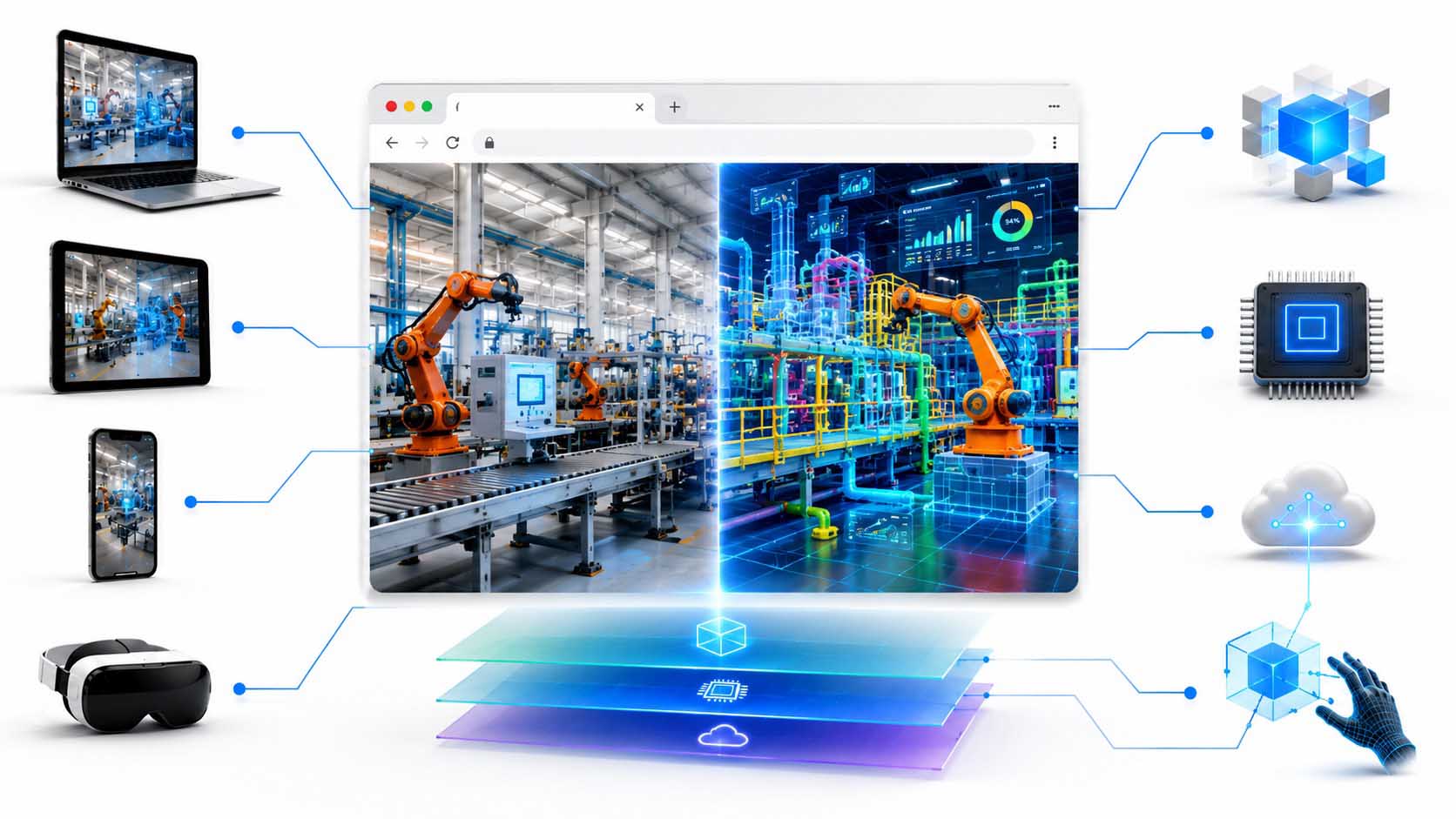
A traditional web browser is evolving into a spatial information platform. Real production facilities, Digital Twins, real-time data and browser-based 3D applications merge into a shared working environment that can be used equally on desktops, tablets, smartphones and mixed reality devices.
Visualization: From the traditional web browser to the Spatial Web – WebXR and WebGPU combine real-time 3D, Digital Twins and browser-based collaboration into a shared spatial information platform | Graphic: © Ulrich Buckenlei | XR Stager Online Magazine | VISORIC GmbH
The significance of this development extends far beyond industrial applications. The same technologies enable interactive product configurators, virtual showrooms, digital real estate, intelligent maintenance platforms, museum tours, smart buildings, healthcare applications and browser-based training systems. Wherever people need to understand and collaboratively work with complex spatial information, the Spatial Web creates entirely new possibilities for visualization and collaboration.
It is particularly important that these applications are based on open web standards. Companies do not develop isolated specialist solutions for individual devices, but browser-based platforms that can flexibly adapt to different devices and future technologies. This creates durable digital infrastructures that can be continuously expanded and integrated into existing business processes.
- Websites are evolving from static information pages into interactive spatial platforms.
- WebXR enables browser-based 3D applications on desktops, smartphones, tablets and mixed reality devices.
- WebGPU delivers the graphics performance required for highly complex real-time 3D visualizations directly within the browser.
- Digital Twins connect spatial models with real-time data and create shared information environments.
- Open web standards form the foundation of the future Spatial Web and cross-device collaboration.
Now that the technological foundation has been established, the next question arises: Why are spatial user interfaces increasingly becoming the more intuitive form of communicating information? The next chapter explores precisely this development.
Why 3D Is Becoming the New Interface
For decades, digital user interfaces have been based on documents. Information is presented in tables, lists, diagrams, forms and individual windows. This concept has proven effective for word processing, accounting and traditional office applications. However, when machines, buildings, production facilities or technical processes need to be understood, analyzed and edited collaboratively, two-dimensional presentation increasingly reaches its limits.
After all, people do not perceive their surroundings as tables, but spatially. Distances, proportions, movements and relationships are understood intuitively through spatial perception. Modern 3D web technologies take advantage of precisely this benefit. Instead of displaying information separately from the object to which it belongs, the information is presented directly where it originates. Temperature, energy consumption, maintenance conditions or sensor data appear directly on the relevant machine and can therefore be understood much more quickly.[5]
This development is made possible by open web standards such as glTF and modern browser technologies. glTF has become established as an efficient industry standard for exchanging interactive 3D models and enables complex scenes to be displayed quickly within the browser. At the same time, new technologies such as the WebXR Layers API ensure that spatial user interfaces can be displayed with high performance, a clear structure and independently of the device being used.[6]
The following visualization illustrates this fundamental transformation. On the left side, a user works with traditional two-dimensional user interfaces. Multiple windows containing tables, diagrams, documents and technical drawings must be viewed simultaneously and mentally connected with one another. Information is distributed across different sources and requires continuous mental translation between the data and the real machine.
On the right, the same task is presented through an entirely different form of interaction. The user views the Digital Twin of a turbine directly as a three-dimensional object. Operational data, temperature, energy consumption, maintenance information and AI recommendations appear directly on the relevant component. Instead of switching between different applications, the user interacts directly with the object itself. Information is therefore not only displayed but experienced spatially.
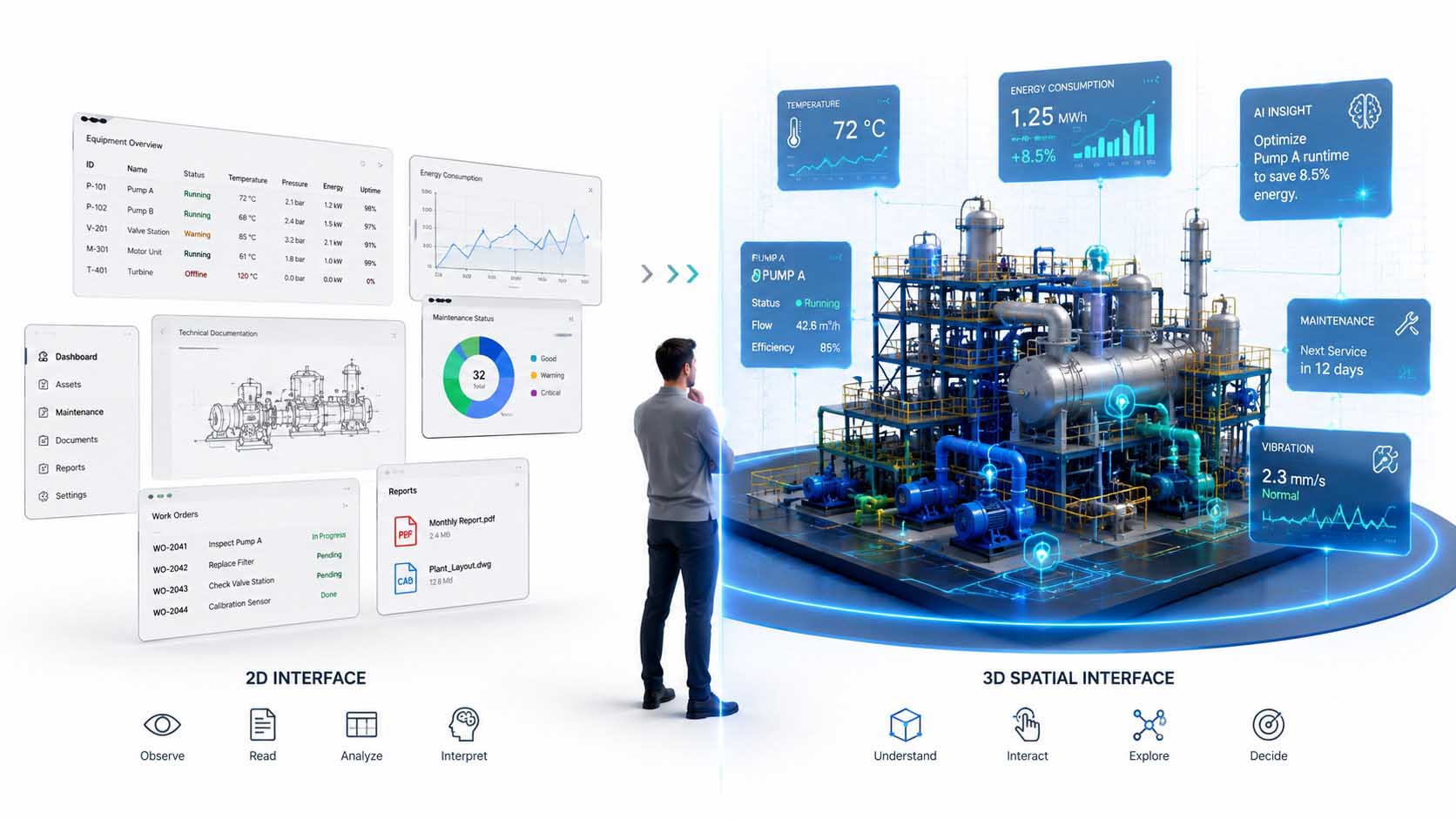
The transition from traditional 2D user interfaces to spatial 3D interfaces. While information was previously displayed in separate windows, tables and documents, the Spatial Web combines Digital Twins, real-time data and Artificial Intelligence within a shared interactive workspace.
Infographic: Spatial user interfaces connect Digital Twins, real-time data and Artificial Intelligence directly with the real object, creating a more intuitive form of information communication | Graphic: © Ulrich Buckenlei | XR Stager Online Magazine | VISORIC GmbH
This difference becomes particularly evident in complex industrial facilities. While traditional applications require numerous dashboards to be opened simultaneously, a spatial interface combines all relevant information within a shared context. Relationships become immediately visible because data is no longer separated from its point of reference. Users can see at a glance which component is affected, which measurements have changed and what consequences may result.
This is complemented by a new form of interaction. Users no longer navigate exclusively through menus, but rotate models, zoom into assemblies, show or hide individual components and examine technical relationships directly within the Digital Twin. The spatial model itself becomes the user interface. This significantly reduces cognitive effort because information appears exactly where it is actually needed.
Another advantage lies in device independence. The same application can be used on desktop PCs, tablets, smartphones or mixed reality devices. The spatial model remains identical, while only the presentation automatically adapts to the respective device. Companies therefore no longer develop different applications, but a shared browser-based platform for all usage scenarios.
This development opens up far more possibilities than visualization alone. Interactive 3D interfaces support engineering, product development, maintenance, sales, training, remote assistance, smart buildings and digital service platforms alike. Wherever people need to understand complex spatial relationships, more intuitive and efficient workflows become possible.
The Spatial Web therefore changes not only the technology behind modern websites, but also the way people absorb information and make decisions. Traditional user interfaces become spatial information environments in which data, models and Artificial Intelligence merge into a shared user experience.
- Spatial user interfaces are based on the natural way people perceive their surroundings.
- glTF enables efficient interactive 3D models as the foundation of modern web applications.
- WebXR Layers displays complex spatial user interfaces with high performance across different devices.
- Digital Twins connect information directly with the relevant object instead of separate dashboards.
- The 3D model itself becomes an intuitive user interface for analysis, interaction and collaboration.
When information is no longer merely displayed but continuously synchronized with the real world, the next stage in the development of the Spatial Web emerges: the Digital Twin. The next chapter shows how an interactive 3D model becomes a dynamic representation of real products, machines and processes.
Digital Twins Are Becoming Interactive Web Platforms
Interactive 3D models form the foundation of modern spatial applications. However, they only reveal their true value when they are continuously connected with the real world. A static visualization thereby becomes a Digital Twin that not only represents real facilities, products or buildings, but also reflects their current condition, makes changes traceable and provides information in real time.[7]
This is precisely what distinguishes a Digital Twin from an ordinary 3D model. While a model merely describes geometry and appearance, a Digital Twin additionally connects sensor data, process information, operating conditions and historical events with its digital representation. The virtual object therefore continuously evolves together with its real-world counterpart and becomes a shared source of information for a wide range of specialist departments.
Modern web technologies now make it possible to provide these Digital Twins directly within the browser. Users no longer require specialized software, but access the same models, real-time data and analytics through a shared browser-based platform. Engineering, production, service, management and customers therefore work with identical information and make decisions based on a shared data foundation.
The following infographic illustrates this transformation particularly clearly. On the left side, information from the real world converges. Machines, sensors, control systems, employees and environmental data continuously provide current information. At the center, this information is used to create the Digital Twin of an industrial facility. The browser window represents the shared platform through which all participants access the same spatial information base.
The right side demonstrates the wide range of ways in which this information can be used. The same platform supports engineering, operations, maintenance, training, Artificial Intelligence and cross-location collaboration. Instead of using several separate applications, all departments access the same Digital Twin. This creates consistent data, transparent processes and significantly more efficient collaboration.
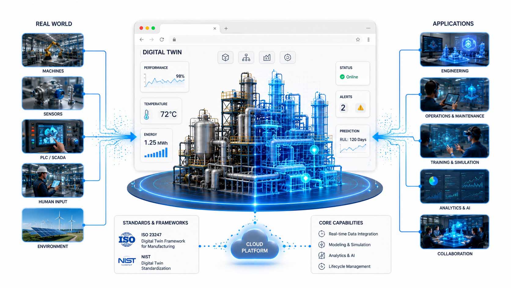
A Digital Twin connects real machines, sensors and process data with a browser-based platform. Engineering, operations, maintenance, training and Artificial Intelligence simultaneously access the same spatial information base and work within a shared Digital Twin.
Infographic: Browser-based Digital Twins connect real facilities, real-time data and industrial applications within a shared spatial platform in accordance with ISO 23247 and the NIST standardization approaches | Graphic: © Ulrich Buckenlei | XR Stager Online Magazine | VISORIC GmbH
The international ISO 23247 standard describes precisely this approach for industrial applications. According to the standard, a Digital Twin does not consist solely of a virtual model, but connects physical systems, digital representations and continuous data streams within a shared architecture. The goal is to make information consistently available throughout the entire lifecycle of a product or production facility and to use it for simulations, analyses and operational decisions.
In parallel, the National Institute of Standards and Technology (NIST) is working on the consistent standardization of Digital Twins. The focus lies on interoperability, open interfaces and shared information models. In the future, Digital Twins should function independently of individual manufacturers and exchange information between different software platforms, machines and organizations.[8]
Digital Twins therefore also change the role of traditional enterprise software. Information no longer remains isolated within individual applications or databases, but is brought together within a shared spatial model. Maintenance data, sensor measurements, documentation, production metrics and AI analyses relate directly to the relevant object and can therefore be understood much more intuitively.
This approach becomes particularly valuable in complex industrial facilities. Instead of evaluating different dashboards, tables or reports in parallel, engineers and service teams view the current condition directly within the Digital Twin. Critical components are highlighted, measurements appear directly on the relevant component and changes can be traced spatially. This significantly reduces the effort required for interpretation and enables faster decisions.
At the same time, entirely new possibilities for collaboration emerge. Multiple people access the same Digital Twin regardless of their location, analyze identical information and can immediately discuss changes together. Browser-based platforms therefore become a central working environment in which development, production, service and management collaborate on the basis of shared information.
Digital Twins are thus evolving from technical visualizations into intelligent web platforms. They connect real objects, real-time data and people within a shared spatial information environment and create the foundation for the next generation of digital business processes.
- Digital Twins continuously connect real facilities with current operational and sensor data.
- Browser-based platforms provide shared access to the same Digital Twin.
- Engineering, production, service and management work with a consistent spatial information base.
- ISO 23247 and NIST establish international foundations for interoperable Digital Twins.
- Interactive web platforms replace isolated information silos with shared digital workspaces.
However, a Digital Twin does not merely represent the current condition of a system. Its full potential only emerges when Artificial Intelligence analyzes the available information, identifies relationships and actively supports people in making decisions. The next chapter shows how spatial applications become intelligent in this way.
Artificial Intelligence Makes Spatial Applications Intelligent
Digital Twins create a shared spatial information base for machines, facilities, buildings and processes. They display current conditions, connect geometry with real-time data and make it possible to understand complex relationships directly on the relevant object. The next stage of development begins when Artificial Intelligence no longer merely displays this information, but independently analyzes and evaluates it and translates it into specific recommendations for action.
This fundamentally changes the role of spatial applications. An interactive 3D visualization becomes an intelligent assistance system. The application identifies anomalies, compares current measurements with historical data, simulates possible developments and supports users in selecting appropriate measures. Information therefore not only becomes spatially visible but also gains specific relevance for operations, maintenance and decision-making processes.[9]
The foundation for this is created by connecting different data sources. Sensors provide current measurements, control systems describe the operating condition, enterprise systems provide production and maintenance information, and historical data shows how a facility behaved in comparable situations. The Digital Twin spatially assigns this information to the relevant machines and components. Artificial Intelligence then analyzes the relationships.
The following infographic illustrates this interaction using an industrial facility as an example. On the left side, information from sensors, PLC and SCADA systems, production software, historical databases and connected devices flows into the shared platform. At the center is the Digital Twin of the facility. A prominently highlighted pump indicates that the system has detected increased vibration and assigned it directly to the affected component.
At the same time, Artificial Intelligence evaluates the potential cause of the anomaly. It compares current and historical measurements, calculates the probability of failure and recommends appropriate measures. In addition to predictive maintenance, the system can also optimize energy consumption, flow rates and plant performance. Simulations demonstrate the potential impact of a change before it is implemented in the real facility.
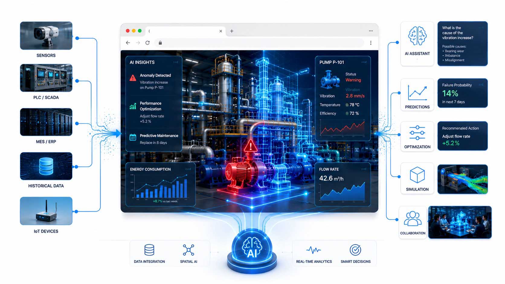
Artificial Intelligence connects sensor data, control systems and historical information with the Digital Twin of a facility. Anomalies become visible directly on the affected component, potential causes are analyzed and appropriate measures for maintenance, simulation and optimization are recommended.
Infographic: Spatial AI enhances browser-based Digital Twins with real-time analysis, predictive maintenance, simulation and intelligent decision support | Graphic: © Ulrich Buckenlei | XR Stager Online Magazine | VISORIC GmbH
The spatial assignment of analysis results is particularly valuable. In traditional dashboards, a warning often appears merely as a row, metric or diagram. Within an intelligent Digital Twin, it becomes immediately visible which component is affected, where it is located and which neighboring systems may also be relevant. This reduces the effort required for interpretation and makes it possible to identify the cause of a malfunction more quickly.
Artificial Intelligence can perform a variety of tasks in this context. It identifies unusual patterns, predicts potential failures and analyzes which parameters influence the performance or energy consumption of a facility. At the same time, it can use natural language to explain complex technical relationships in an understandable way. Users can, for example, ask about the cause of increased vibration and receive a context-specific answer directly within the spatial model.
Another important component is simulation. Physically accurate Digital Twins make it possible to test different measures virtually before implementing them. Flow rates can be adjusted, maintenance strategies compared and production parameters optimized without affecting the real facility. Platforms such as NVIDIA Omniverse combine real-time 3D, physical simulation and Industrial AI within a shared virtual environment for this purpose.[10]
Microsoft Azure Digital Twins also follows the approach of representing connected physical environments through semantic information models. Machines, rooms, sensors and business processes are not viewed merely as individual data points, but are connected through their relationships. This allows Artificial Intelligence to identify connections that would be difficult to detect within separate systems.
For companies, this creates a new form of digital decision support. Maintenance teams receive early indications of potential faults, production managers identify optimization opportunities and management can understand the effects on performance, energy consumption and availability. All participants access the same Digital Twin and the same current information base.
It remains essential that Artificial Intelligence does not operate in isolation. Its recommendations must be presented transparently and be available for human evaluation. The Digital Twin provides a particularly suitable context for this because analysis results are directly connected with the affected objects, measurements and processes. Abstract AI results are thereby transformed into understandable spatial relationships.
- Artificial Intelligence analyzes real-time data directly within the Digital Twin.
- Anomalies and risks are spatially assigned to the affected component.
- Historical data enables forecasting, predictive maintenance and early fault detection.
- Simulations test potential measures before they are transferred to the real facility.
- Spatial AI assistants explain relationships and support people in making well-informed decisions.
The Digital Twin therefore evolves from an interactive representation into an intelligent spatial platform. However, its value is not limited to individual machines or facilities. When the same technology is used in engineering, sales, service and digital services, it creates a shared platform for the entire lifecycle. The next chapter demonstrates how diverse these applications already are today.
A Platform for Industry, Sales and Digital Services
The true value of browser-based Digital Twins does not emerge within a single application, but through their use across the entire product and asset lifecycle. While 3D models were previously used primarily in design and engineering, modern Digital Twins are now evolving into a shared spatial information platform for engineering, production, sales and digital services. Different departments access the same models, real-time data and AI-supported analyses and work on the basis of shared information.[11]
This development fundamentally changes the role of the Digital Twin. It no longer serves exclusively to visualize technical relationships, but becomes the central platform on which information from a wide range of business areas is brought together. Engineering, manufacturing, sales, service and management no longer work with separate data sets, but access the same digital representation of a product or facility.
The following infographic illustrates this platform concept through six typical application areas. At the center is a browser-based Spatial Web platform with a Digital Twin. Six different fields of application branch out from it and together cover the entire lifecycle of an industrial product. The graphic deliberately does not show a linear process chain, but an open digital ecosystem in which all applications access the same spatial information platform.
The two examples on the left represent industrial applications. In the upper section, a modern production line with robots is shown, with machine conditions continuously monitored through a Digital Twin. Production metrics, equipment utilization and performance data appear directly within the spatial model and enable the continuous optimization of manufacturing processes. Below, the graphic shows an electrical machine whose operating condition is analyzed by Artificial Intelligence. Predictive maintenance identifies potential failures at an early stage and recommends suitable service intervals before unplanned downtime occurs.
The two application examples on the right illustrate the added value for sales and customer communication. At the top, prospective customers configure a complex industrial product directly within an interactive 3D model. Variants, equipment options and functions can be visualized immediately and discussed together with the customer. Below, a browser-based Configure-Price-Quote solution supports quotation creation. Products are no longer explained solely through technical data sheets, but can already be experienced as interactive Digital Twins during the sales process.
In the lower section, the platform expands to include digital services. On the left, a service technician uses spatial information to support a remote colleague. Both access the same Digital Twin simultaneously and analyze the facility independently of their location. On the right, the infographic shows a modern service portal that combines maintenance information, operating data, documentation and condition analyses within a shared browser-based interface. A traditional customer portal becomes an intelligent service platform that supports the entire lifecycle of the facility.
At the center, the platform connects all applications with one another. Engineering, production, sales and service no longer work with separate software solutions, but access the same geometry data, real-time information and AI models. Changes automatically become visible to all participants. This creates a continuous flow of information across the entire lifecycle of a product, from initial design and manufacturing to commissioning, maintenance, modernization and digital service.
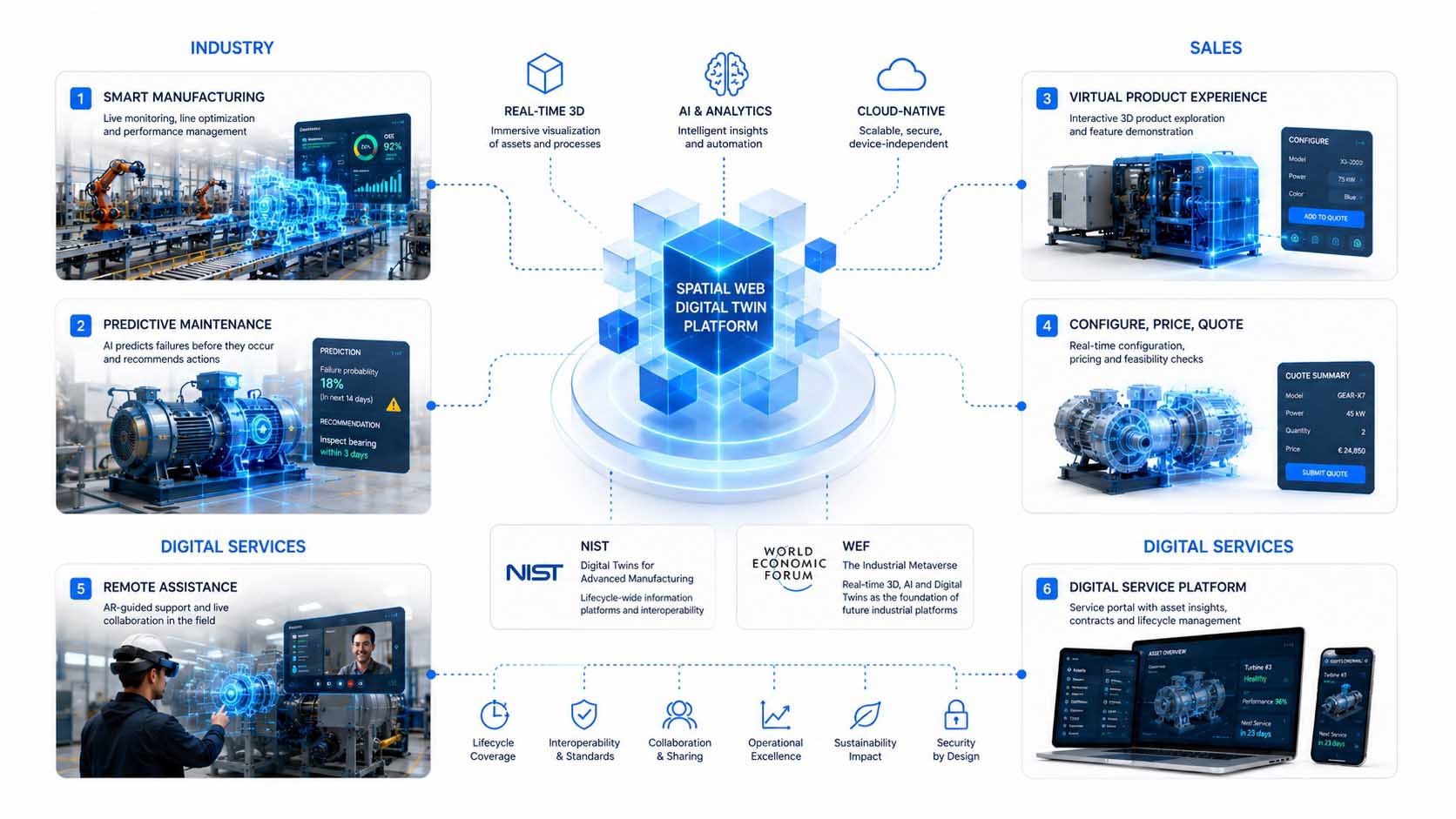
A shared Spatial Web platform connects engineering, production, sales and digital services through the same Digital Twin. Different business areas access identical spatial information, real-time data and AI-supported analyses and support products throughout their entire lifecycle.
Infographic: Browser-based platform for industry, sales and digital services with Digital Twins, real-time data and Artificial Intelligence across the entire product and asset lifecycle | Graphic: © Ulrich Buckenlei | XR Stager Online Magazine | VISORIC GmbH
This platform strategy reflects current developments in international standardization and industry initiatives. The National Institute of Standards and Technology (NIST) increasingly describes Digital Twins as a shared information platform for the entire product and asset lifecycle. Data should no longer remain within individual applications, but become available across organizations and connect different specialist departments.
The World Economic Forum also regards real-time 3D, Artificial Intelligence and Digital Twins as the technological foundation of future industrial platforms. Spatial information models are evolving into a shared infrastructure on which engineering, production, sales and service collaborate. This creates entirely new digital business models in which products are no longer merely sold, but supported throughout their entire lifecycle.[12]
For companies, this approach offers significant advantages. Information does not need to be maintained multiple times, changes are immediately available to all participants and decisions are based on a consistent data foundation. At the same time, new opportunities emerge for digital services, remote services, predictive maintenance, virtual product presentations and browser-based self-service portals.
The Digital Twin therefore evolves from a technical visualization into an enterprise-wide platform. It connects people, processes and intelligent systems within a shared spatial information environment and creates the foundation for fully connected digital value creation.
- Digital Twins are evolving into shared platforms for engineering, production, sales and service.
- All business areas access the same spatial models, real-time data and AI analyses.
- Interactive 3D applications improve industrial processes as well as sales and customer communication.
- Browser-based service platforms support products throughout their entire lifecycle.
- The Spatial Web creates a shared digital infrastructure for future industrial business models.
When Digital Twins become available across the entire organization, the next logical stage of development emerges. People at different locations work simultaneously within the same spatial information environment. The next chapter shows how Spatial Computing fundamentally changes collaboration.
Collaboration Becomes Spatial
Digital Twins change not only the way information is presented, but also the way people collaborate. While traditional video conferences or screen sharing transmit two-dimensional content, Spatial Computing creates shared three-dimensional workspaces in which multiple people can simultaneously view, analyze and edit the same objects. The Digital Twin thereby becomes a shared workplace, regardless of where the participants are located.[13]
Browser-based spatial applications enable a new form of collaboration. Engineers, service technicians, production managers and customers simultaneously access the same Digital Twin and see identical information in real time. Changes, markers and comments immediately appear for all participants. Individual screens become a shared spatial information environment.
The following infographic illustrates this principle. At the center is a browser-based Spatial Collaboration platform in which an industrial facility is represented as a Digital Twin. Multiple people access the same model simultaneously, even though they use different devices and are located at different sites. The browser window represents the shared web platform through which all participants are connected.
At the top left, an engineer works directly within the spatial model using a mixed reality headset. She views the facility from her natural perspective and can select or mark components through gestures. Below, a design engineer analyzes the same Digital Twin at a traditional desktop workstation. At the top right, a service technician inspects the facility using a VR headset, while at the bottom right, an employee accesses the same information on a tablet. All participants work simultaneously on the identical model and access the same information base.
Different forms of collaboration become visible at the center of the browser window. Color-coded users indicate which specialist departments are currently connected. Comments, measurements and annotations appear directly on the respective component. Instead of exchanging information by email or screenshot, all participants discuss it directly within the spatial model. The 3D object itself therefore becomes a shared communication platform.
This approach becomes particularly evident in maintenance or engineering processes. A service technician on site can mark an anomaly directly within the Digital Twin. Engineers at the company location immediately see the same marker, add comments or display additional technical information. Decisions are therefore no longer based on individual images or documents, but on a shared spatial context.
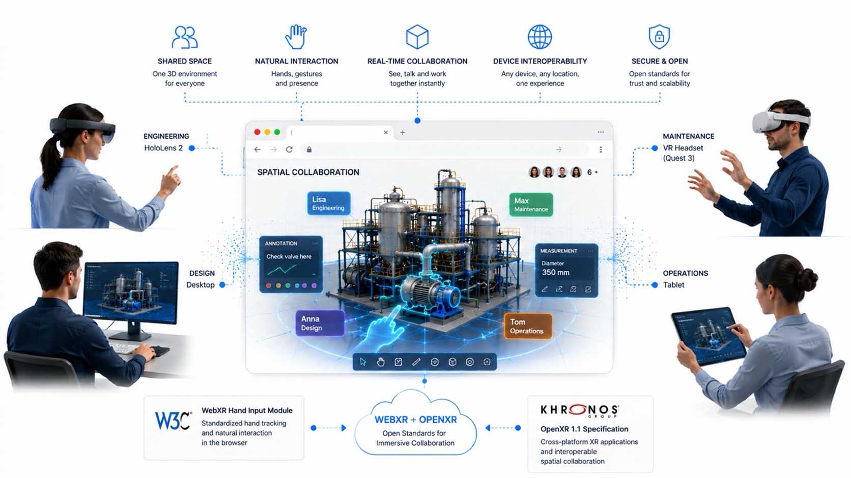
Browser-based Spatial Computing platforms connect people, Digital Twins and different devices within a shared spatial workspace. Engineering, service, production and management access the same Digital Twin simultaneously and collaborate in real time.
Infographic: WebXR and OpenXR enable cross-device spatial collaboration with natural gestures, Digital Twins and browser-based 3D applications | Graphic: © Ulrich Buckenlei | XR Stager Online Magazine | VISORIC GmbH
A key foundation for this is the WebXR Hand Input Module of the World Wide Web Consortium. It standardizes the tracking of hands and gestures within browser-based spatial applications. Users can therefore grab, rotate, move or scale objects without relying on traditional input devices. Interaction increasingly follows natural movements and makes spatial applications more intuitive to use.
The OpenXR standard of the Khronos Group is equally important. It ensures that spatial applications are not tied to a specific device or individual manufacturer. Browser-based Spatial Web applications can therefore be used on different mixed reality, virtual reality or future XR devices without requiring separate software versions.[14]
This openness is essential for companies. Different departments often use different devices, workstations or operating systems. Open standards nevertheless provide access to the same spatial application and create a platform for collaboration and knowledge exchange that can be used over the long term.
Communication itself also changes. Information is no longer communicated exclusively through documents, presentations or video conferences. Instead, teams discuss it directly within the Digital Twin. Measurements appear on the relevant component, comments remain permanently linked to the object and all participants see the same spatial situation. This significantly reduces coordination effort and makes technical relationships much easier to understand.
This form of collaboration is not limited to industrial facilities. The same technologies are suitable for architecture, construction, healthcare, energy supply, product development, education and digital service platforms. Wherever people need to jointly understand and work with complex spatial information, browser-based Spatial Collaboration platforms create new possibilities for collaboration.
- Digital Twins become a shared spatial workplace for distributed teams.
- WebXR enables natural interaction through hands, gestures and browser-based 3D applications.
- OpenXR ensures cross-device interoperability and long-term investment protection.
- Multiple users edit the same Digital Twin simultaneously in real time.
- Spatial collaboration improves communication, understanding and shared decision-making.
When people work together within the same Digital Twin regardless of their location, the foundation is created for a new generation of digital platforms. The next chapter shows the specific fields of application in which these technologies are already creating measurable economic benefits today.
Open Standards Instead of Isolated Solutions
The long-term success of browser-based 3D platforms does not depend solely on powerful hardware, fast networks or Artificial Intelligence. The decisive factor is the ability to exchange information between different software solutions, CAD systems, cloud platforms and devices without loss. This is precisely where open standards play a key role. They ensure that Digital Twins do not remain locked within individual vendor solutions, but become a shared spatial information platform for industry as a whole.[15]
For many years, companies created numerous separate data silos. Design, simulation, production, sales and service often worked with their own file formats and proprietary software solutions. Every change had to be transferred, converted or manually reworked multiple times. This created media discontinuities, information loss and high integration costs.
Modern Spatial Web platforms follow a different approach. Instead of closed systems, open ecosystems are emerging in which a wide range of applications can access the same Digital Twin. Open standards provide a common language for this purpose. They enable the exchange of geometry, material properties, metadata, animations, hierarchies and other information across the entire product lifecycle.
The following infographic illustrates this principle. On the left side are typical data sources within a company. CAD systems provide design data, BIM models describe buildings and infrastructure, PLM systems manage product information, reality capture processes create digital representations of real objects, sensors continuously provide real-time data and APIs connect additional enterprise systems. Each of these sources generates valuable information that initially exists independently.
At the center of the visualization, these different information streams are brought together. The two interlocking building blocks symbolize the connection of open standards within a shared spatial data model. They do not represent individual vendor products, but the ability to connect different data environments in an interoperable way. Many separate data sources thereby become a consistent Digital Twin that organizes all information within a shared spatial structure.
On the right side, the graphic shows the different target platforms. The same Digital Twin can then be used without media discontinuities within web applications, XR systems, desktop software, mobile applications, game engines and cloud platforms. Instead of building a separate data foundation for each device or software application, all systems access the same spatial information source. This keeps information consistent, makes changes immediately visible and allows new applications to be developed much more quickly.

Open standards connect data from CAD, BIM, PLM, reality capture, sensors and enterprise systems into a shared Digital Twin. The same spatial information base can then be used across web, desktop, mobile, XR and cloud platforms.
Infographic: Interoperable Spatial Web platform connects different industrial data sources through open standards into a shared spatial information platform for web, XR, mobile, desktop and cloud | Graphic: © Ulrich Buckenlei | XR Stager Online Magazine | VISORIC GmbH
OpenUSD plays a central role in this process. The open framework was developed to efficiently organize complex three-dimensional scenes, Digital Twins and extensive technical data models. Multiple applications can simultaneously access the same information, synchronize changes and combine different specialist models within a shared spatial structure. This makes OpenUSD particularly suitable for collaborative engineering and industrial platforms.
The glTF ecosystem of the Khronos Group is equally important. While OpenUSD supports complex production and collaboration processes, glTF enables the efficient delivery of interactive 3D content for web browsers, mobile devices, desktop applications and XR systems. Models can be transferred quickly, displayed directly and used across a wide range of applications without complex conversions. The two standards therefore complement one another ideally within modern Spatial Web platforms.[16]
For companies, this development represents a fundamental strategic shift. In the future, investments will focus less on individual software products and more on open information platforms. Data becomes usable independently of individual vendors, existing systems can be integrated more easily and future technologies can be incorporated without complete redevelopment.
This creates long-term investment protection. Digital Twins remain usable for many years, even when individual applications or hardware platforms change. At the same time, open standards significantly reduce the integration effort between engineering, production, sales and service and create the foundation for scalable browser-based Spatial Computing platforms.
- Open standards prevent data silos and create interoperable spatial information platforms.
- CAD, BIM, PLM, sensor data and reality capture are combined within a shared Digital Twin.
- The same data foundation can be used across web, XR, desktop, mobile and cloud platforms.
- OpenUSD and glTF complement one another as the foundation of modern Spatial Web ecosystems.
- Interoperability creates investment protection and simplifies the long-term digitalization of industrial processes.
Open standards therefore form the foundation of future Spatial Web platforms. The final chapter shows why this is developing into far more than a new visualization technology, namely a shared spatial information infrastructure for the digital economy of tomorrow.
The Spatial Web as the Next Evolutionary Stage of the Internet
The development of the internet has so far been shaped primarily by text, images, videos and two-dimensional user interfaces. Websites were read, forms were completed and information was displayed on flat screens. Spatial Computing now marks the beginning of a new stage of development. Digital content is increasingly moving beyond traditional websites and evolving into interactive three-dimensional information environments in which people, Digital Twins and Artificial Intelligence work together. The Spatial Web therefore does not extend the existing internet through a single new technology, but through an entirely new form of interaction.[17]
While today’s web applications primarily present documents and media, future Spatial Web platforms will connect real objects, Digital Twins, sensors, Artificial Intelligence and spatial user interfaces within a shared information layer. Information will no longer appear exclusively on websites, but directly on the relevant object, within a factory, building, product or entire city. The internet thereby evolves from an information network into a spatial infrastructure.
The following infographic clearly summarizes this development. At the center is a spatial platform symbolizing the Spatial Web. It connects a wide range of application areas within a shared digital ecosystem. The network illustrates that all applications are based on the same open web technologies and no longer operate separately from one another.
Different application areas are shown around this central platform. At the top left, industry uses browser-based Digital Twins for the planning, simulation and optimization of technical facilities. Below, architecture and construction benefit from interactive building models that can already be edited collaboratively during the planning phase. In education, immersive learning platforms are emerging on which complex content can be communicated spatially and developed collaboratively.
On the right side, this principle extends to additional sectors. In healthcare, spatial models support diagnosis, training and medical planning. In retail, interactive product models enable new forms of customer consultation and configuration. In collaboration, teams access the same Digital Twin simultaneously regardless of their location and work within a shared spatial information environment.
The lower section of the graphic shows the technological foundation of this development. Open web technologies form the basis of the Spatial Web. HTML, Web APIs, WebGL, WebXR, modern input methods, real-time communication and cloud infrastructures complement one another to create an open platform that functions independently of individual vendors or devices. This openness is precisely what makes the Spatial Web scalable over the long term and enables innovation across company and industry boundaries.
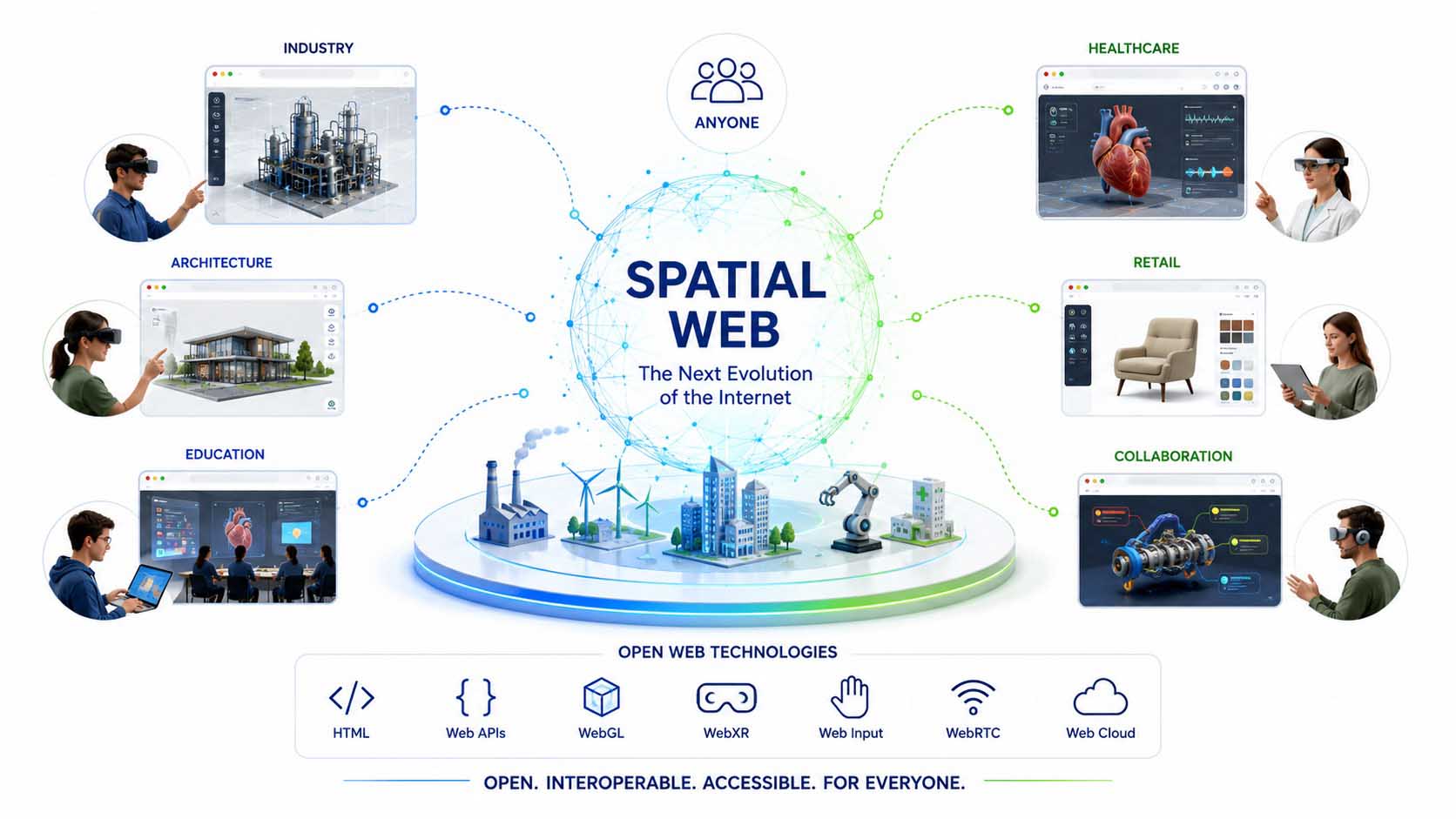
The Spatial Web connects Digital Twins, spatial user interfaces and open web technologies within a shared information platform. Different industries access the same technological foundation and create entirely new forms of collaboration, communication and digital value creation.
Infographic: The Spatial Web connects industry, architecture, education, healthcare, retail and collaborative working environments through open web standards within a shared spatial information platform | Graphic: © Ulrich Buckenlei | XR Stager Online Magazine | VISORIC GmbH
Open standards are essential to this development. Through its Immersive Web technologies, the World Wide Web Consortium is developing the foundation for making spatial applications directly available within the browser. This creates platform-independent solutions that can be used across a wide range of devices while preserving the open nature of the internet.
Current research also identifies this as the foundation of future Spatial Web platforms. WebXR, modern web technologies and open network architectures enable an interoperable spatial internet in which people, companies and digital systems can collaborate without proprietary isolated solutions. Digital Twins thereby become a natural component of future web applications and evolve from individual visualizations into a universal spatial information layer.[18]
For companies, this development means far more than introducing new user interfaces. Websites increasingly become interactive workspaces. Product catalogs evolve into Digital Twins. Service portals become collaborative platforms. Engineering, sales, maintenance, training and customer communication will access the same spatial information base and work within a shared digital ecosystem.
This also changes the role of the web browser. It evolves from a document viewer into a universal runtime environment for Spatial Computing. High-performance 3D graphics, Artificial Intelligence, real-time communication and browser-based Digital Twins merge into a platform that works equally well on desktop computers, tablets, smartphones and future XR devices.
The Spatial Web therefore does not represent the replacement of the existing internet, but its logical evolution. Information remains open, accessible and globally available, but in the future it will be presented spatially, intelligently connected and made directly usable within the respective application context. This is where the potential of the next evolutionary stage of the web lies.
- The Spatial Web extends the traditional internet with spatial user interfaces and Digital Twins.
- Industry, architecture, education, healthcare, retail and collaboration access the same open web platform.
- WebXR and modern web standards create interoperable browser-based Spatial Computing applications.
- Open technologies prevent new isolated solutions and protect long-term investments.
- The web browser evolves into a universal platform for spatial digital collaboration.
This brings the article full circle. What begins today with browser-based Digital Twins, open standards and spatial user interfaces is gradually developing into a new generation of the internet. The Spatial Web connects people, information and intelligent systems within a shared spatial information platform that is open, interoperable and applicable across almost every industry.
When Websites Become Interactive 3D Experiences
The previous chapters have shown how open web standards, Digital Twins, real-time 3D, Artificial Intelligence and browser-based Spatial Computing technologies are gradually converging into a shared spatial information platform. However, the true potential of these technologies only becomes fully apparent when they come together within a real-world application.
The following demonstration video presents exactly such a use case. Instead of traditional seating charts or static photographs, it showcases a fully interactive Digital Twin of a stadium that can be accessed directly within a web browser. Visitors can freely navigate the environment, compare different seating locations and realistically experience the actual view of the field or stage before purchasing a ticket.
The application shown is based on modern web technologies such as WebXR, real-time 3D and Artificial Intelligence. As a result, it runs directly within the browser without requiring specialized software installation and can be used on desktop computers, tablets, smartphones or future XR devices. At the same time, the Digital Twin not only represents the stadium’s geometry but also connects it with additional information such as seating data, navigation, event information and intelligent assistance features.
Particularly interesting is the combination of multiple technologies. Real-time 3D renders the Digital Twin, WebXR enables spatial interaction directly within the browser and Artificial Intelligence assists visitors with navigation, answers questions and recommends suitable seating options. A traditional ticketing platform thereby becomes an intelligent digital experience environment.
Even more important, however, is the transferability of this concept. The stadium serves merely as an illustrative example. The same technological foundation can also be applied to museums, airports, universities, hospitals, industrial facilities, logistics centers, smart cities or complex manufacturing environments. Wherever people need to understand, plan or experience real places, browser-based Digital Twins create significant added value.
Video: Browser-based Digital Twin of a stadium powered by WebXR, real-time 3D and Artificial Intelligence | Video inspiration: @innovation (Instagram) | Analysis, narration, editorial work and video editing: © Ulrich Buckenlei | XR Stager Online Magazine | VISORIC GmbH
The video clearly demonstrates how the role of traditional websites is changing. Instead of presenting information exclusively through lists, forms or images, users increasingly move directly within interactive three-dimensional information environments. Digital Twins therefore evolve from technical visualizations into intuitive user interfaces that make spatial understanding significantly easier.
For companies, this opens entirely new opportunities. Customers can realistically experience products, buildings or event venues before visiting them. Service technicians access Digital Twins of complex facilities directly within the browser. Sales teams present interactive product models instead of static catalogs. Employees collaborate within the same spatial environment regardless of whether they use a desktop PC, tablet or XR headset.
The example also impressively demonstrates the advantages of open web standards. Since all content is executed directly within the browser, there is no need for closed platforms or device-specific isolated solutions. Browser-based Spatial Computing applications can be continuously expanded, updated and deployed across a wide variety of devices. This openness forms one of the most important foundations of the future Spatial Web.
- WebXR transforms traditional websites into interactive spatial user interfaces.
- Digital Twins enable realistic exploration directly within the browser.
- Artificial Intelligence supports navigation, orientation and personalized recommendations.
- The technology is suitable for stadiums, museums, airports, industrial facilities, smart cities and many other application areas.
- Open web standards create platform-independent Spatial Computing applications for virtually any device.
This example illustrates the direction in which the web is evolving. Websites are increasingly becoming intelligent spatial information platforms where people, Digital Twins and Artificial Intelligence interact together. This is the true potential of the Spatial Web: information is no longer simply read—it is experienced.
From an Idea to a Successful Spatial Web Platform
Browser-based 3D applications are not created through individual technologies alone, but through the intelligent combination of open web standards, interactive 3D graphics, Digital Twins, Artificial Intelligence and intuitive user experience design. Only when WebXR, WebGPU, real-time 3D, data platforms and modern web architectures are developed together do powerful Spatial Web applications emerge that deliver real value for companies, customers and employees.
Many successful projects intentionally begin with a clearly defined use case. An interactive product configurator, a browser-based Digital Twin, a virtual showroom, a digital service platform or a spatial sales application provides an ideal pilot project. This makes it possible to validate user experience, performance, data integration and business potential under real-world conditions before gradually expanding the solution into an enterprise-wide Spatial Web platform.
Successful Spatial Web projects combine WebXR, WebGPU, Digital Twins, Artificial Intelligence and real-time 3D into open, browser-based platforms for industry, sales, service and digital customer experiences.
Visualization: Browser-based Spatial Computing platforms powered by WebXR, WebGPU, Digital Twins, Artificial Intelligence and real-time 3D | Image: © Ulrich Buckenlei | XR Stager Online Magazine | VISORIC GmbH
Typical pilot projects for browser-based Spatial Web applications:
- Interactive Digital Twins for industry, buildings and technical facilities.
- Virtual showrooms, product presentations and immersive sales solutions.
- Browser-based service, maintenance and remote support platforms.
- WebXR applications for training, education and spatial collaboration.
- 3D configurators, Smart City platforms and infrastructure solutions.
- Scalable Spatial Web pilot projects as the foundation of future digital transformation strategies.
VISORIC develops professional Spatial Web solutions for industrial enterprises, technology providers and public institutions—from strategic consulting and concept development to UX design and the implementation of powerful enterprise platforms. Our interdisciplinary team of experts in Munich combines modern web technologies with Digital Twins, Artificial Intelligence and real-time 3D to create scalable solutions for a wide range of industries.
- Strategy, consulting and concept development for Spatial Computing and the Spatial Web.
- WebXR, WebGPU and browser-based 3D application development.
- Digital Twins for industry, buildings, infrastructure and Smart Cities.
- Real-time 3D visualization and interactive engineering platforms.
- Artificial Intelligence, Computer Vision and intelligent assistance systems.
- Product configurators, virtual showrooms and digital sales solutions.
- Cloud platforms, APIs and enterprise integration.
- Pilot projects, prototypes and globally scalable enterprise solutions.
Would you like to develop a browser-based Spatial Web application, a Digital Twin or an interactive 3D platform for your organization?
Talk to the VISORIC team of experts in Munich about WebXR, WebGPU, Digital Twins, Artificial Intelligence and modern Spatial Computing platforms. Together, we will transform your idea into a scalable solution for industry, sales, service or digital customer experiences.
Contact:
E-mail: info@visoric.com
Phone: +49 89 21552678
Sources and References
- World Wide Web Consortium (W3C). Immersive Web Working Group. Development of open web standards for spatial user interfaces, WebXR and the future Spatial Web.
- World Wide Web Consortium (W3C). WebXR Device API. Standardized browser-based interface for Virtual Reality, Augmented Reality and spatial applications across desktop, mobile and XR devices.
- Mozilla Developer Network (MDN). WebXR Device API. Introduction to browser-based immersive applications and cross-device development using open web technologies.
- World Wide Web Consortium (W3C). WebGPU. Modern GPU interface for high-performance 3D graphics, visualization and computation directly within the web browser.
- Khronos Group. glTF 2.0 Specification. Open industry standard for efficient 3D models and real-time visualization on the web.
- World Wide Web Consortium (W3C). WebXR Layers API Level 1. Optimized rendering of complex spatial user interfaces and immersive content within the browser.
- ISO 23247. Digital Twin Framework for Manufacturing. International reference architecture for Digital Twins in industrial manufacturing.
- National Institute of Standards and Technology (NIST). Digital Twin Standardization. Standardization, interoperability and application of Digital Twins in industry and infrastructure.
- Microsoft Azure Digital Twins. Modeling intelligent connected physical environments using real-time data, Artificial Intelligence and semantic information models.
- NVIDIA Omniverse Digital Twins. Physically accurate Digital Twins for simulation, Industrial AI and intelligent real-time visualization.
- National Institute of Standards and Technology (NIST). Digital Twins for Advanced Manufacturing. Digital Twins as a shared information platform across the entire product and asset lifecycle.
- World Economic Forum. The Industrial Metaverse. Real-time 3D, Artificial Intelligence and Digital Twins as the foundation of future industrial platforms.
- World Wide Web Consortium (W3C). WebXR Hand Input Module. Standardized hand tracking, gesture recognition and natural interaction for browser-based spatial applications.
- Khronos Group. OpenXR 1.1 Specification. Open standard for interoperable XR applications and cross-device spatial collaboration.
- Alliance for OpenUSD. OpenUSD. Open framework for interoperable 3D scenes, Digital Twins and collaborative real-time platforms.
- Khronos Group. glTF Ecosystem. Open standards for exchanging interactive 3D content across web, CAD, visualization and XR systems.
- World Wide Web Consortium (W3C). Immersive Web Standards. Open web technologies as the foundation for future spatial internet platforms and browser-based Spatial Computing applications.
- Macario, Giuseppe. WebXR, A-Frame and Networked-AFrame as a Basis for an Open Metaverse. Research on open, interoperable Spatial Web platforms based on WebXR and modern web standards.
- VISORIC practical projects in Industrial AI, Spatial Computing, Computer Vision, Digital Twins and Mixed Reality.
- XR Stager platform for real-time 3D, Digital Twins, Knowledge AI and industrial Spatial Computing applications.
Contact Us:
Email: info@xrstager.com
Phone: +49 89 21552678
Contact Persons:
Ulrich Buckenlei (Creative Director)
Mobil +49 152 53532871
Mail: ulrich.buckenlei@xrstager.com
Nataliya Daniltseva (Projekt Manager)
Mobil + 49 176 72805705
Mail: nataliya.daniltseva@xrstager.com
Address:
VISORIC GmbH
Bayerstraße 13
D-80335 Munich